Maps: 1920 - 1939 Latvian & Lithuanian Topographical Maps
During the inter-war period, Lithuanian and Latvian mapmakers leveraged and updated older German
and/or Russian topographical maps, using Lithuanian and Latvian place-names.
and/or Russian topographical maps, using Lithuanian and Latvian place-names.


1200 Palanga 1201 Plunge 1202 Telsiai 1203 Luoke 1204 Siauliai 1205 Radviliskis 1206 Pumpenai 1207 Kupiskis


1300 Klaipeda 1301 Rietavas 1302 Varniai 1303 Kelme 1304 Tytuvenai 1305 Grinkiskis 1306 Panevezys 1307 Subacius


1400 Nida 1401 Katyciai 1402 Taurage N 1403 Erzvilkas 1404 Raseiniai 1405 Kedainiai 1406 Seta 1407 Ukmerge


1501 Pagegai 1502 Taurage S 1503 Jurbarkas 1504 Veliuona 1505 Vilkija 1506 Jonava 1507 Sirvintos


1604 Sakiai 1605 Kaunas 1606 Kaisiadorys 1607 Zasliai


1704 Vilkaviskis 1705 Prienai 1706 Butrimonys 1707 Trakai 1708 Vilnius

1805 Simnas 1806 Alytus
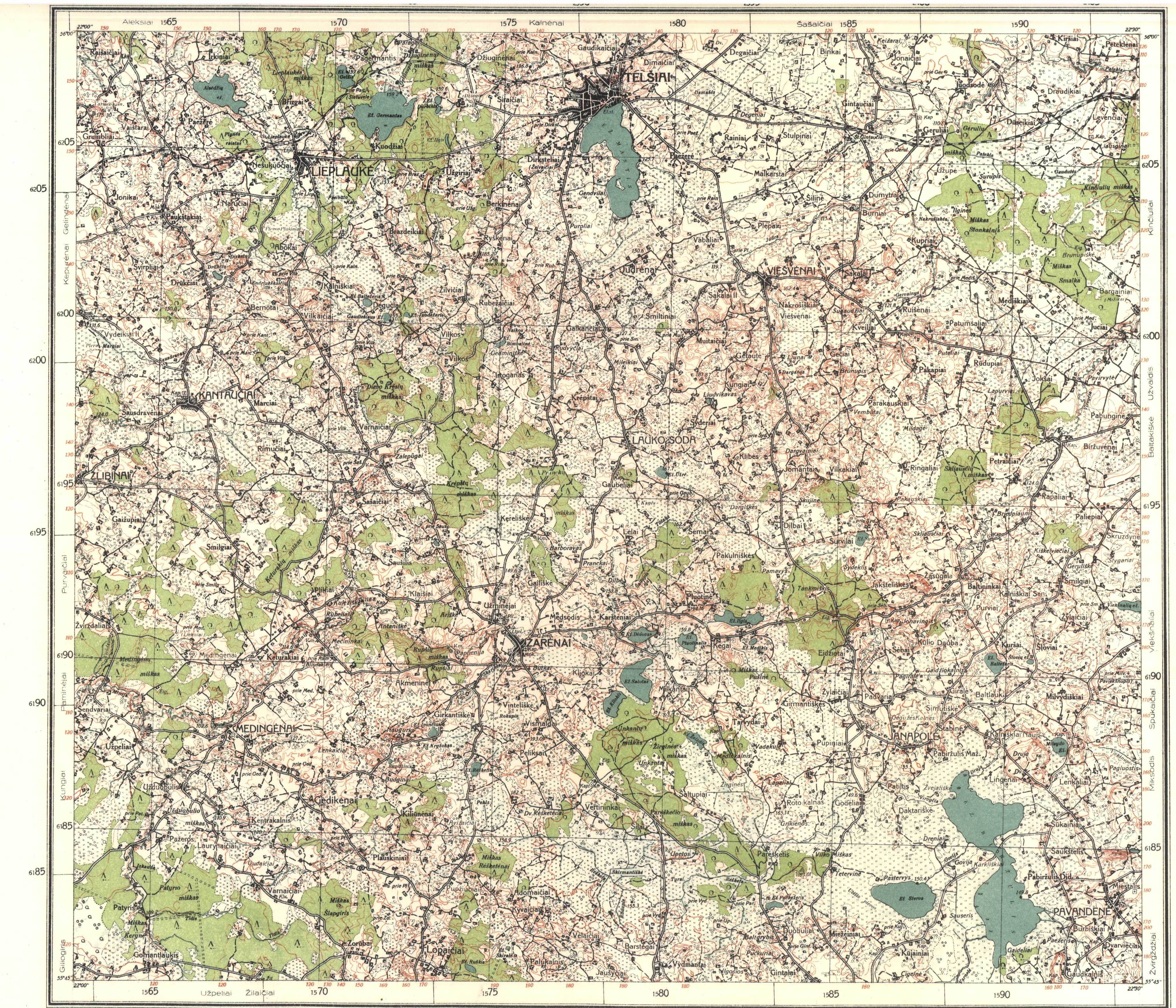
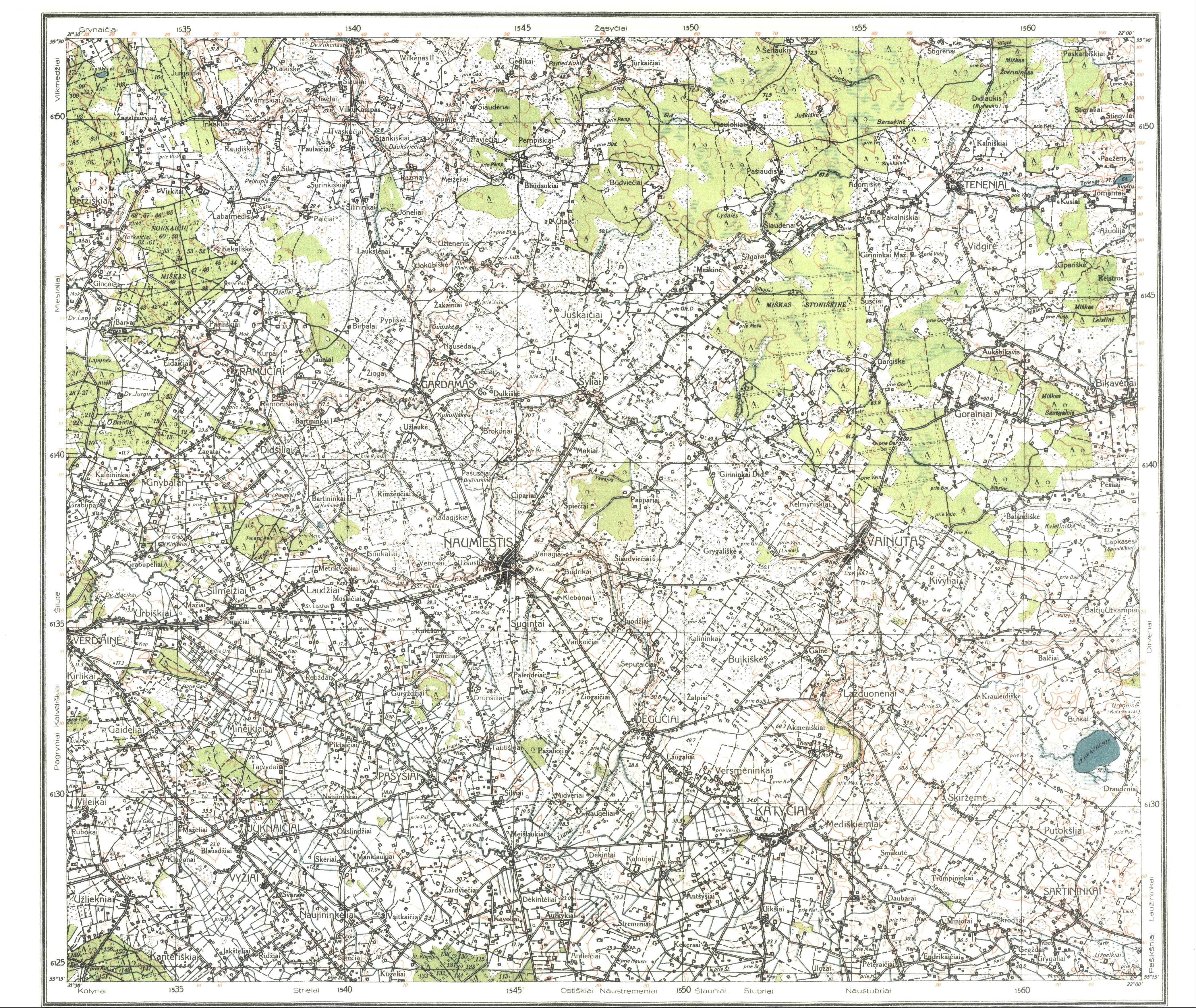
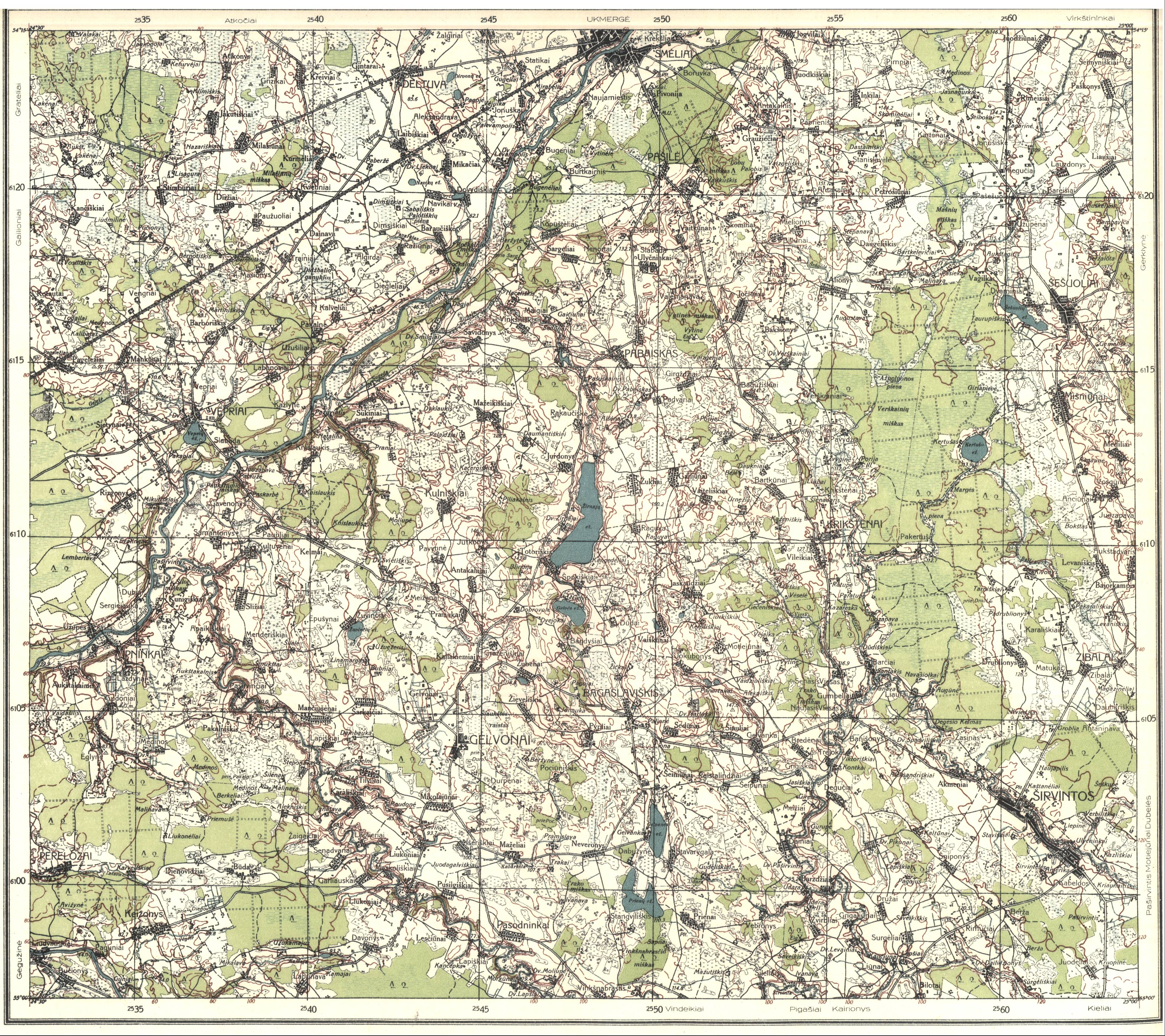
From 1923 -1938 the Lithuanian government began an instrumental topographic survey of Lithuanian territory. Maps at 1:100 000 were compiled for
the whole territory along with 92 sheets at 1:25000. Thumbnails on the right correspond to the map key below left. (AK)
the whole territory along with 92 sheets at 1:25000. Thumbnails on the right correspond to the map key below left. (AK)

005 Liepaja 012 Aizpute 019 Saldus 025 Blidiene 030 Dobele 033 Jelgava 040 Baldone 049 Rembate 058 Jaunjelgava 067 Plavinas 076 Lijograde 085 Varaklani 094 Rezekne 103 Ludza 109 Slabadinci
006 Barta 013 Priekule 020 Ezere 026 Auce 031 Kalnamuiza 034 Platone 041 Bauska 050 Skaistkalne 059 Daudzese 068 Jekabpils 077 Livani 086 Preili 095 Antonopole 104 Kaunata 110 Zilupe
036 Sveiciems 045 Limbazi 054 Valmiera 063 Strencis 072 Gaujiena 081 Ape 090 Veclaicene 099 Batvina
007 Rucava
037 Neibade 046 Straupe 055 Cesis 064 Smiltene 073 Palsmanis 082 Lejaciems 091 Aluksne 100 Kaceni
038 Daugavgriva 047 Sigulda 056 Ieriki 065 Dzerbene 074 Ranka 083 Gulbene 092 Balvi 101 Jaunlatgale
043 Kilingi- Nomme
052 Moisakula
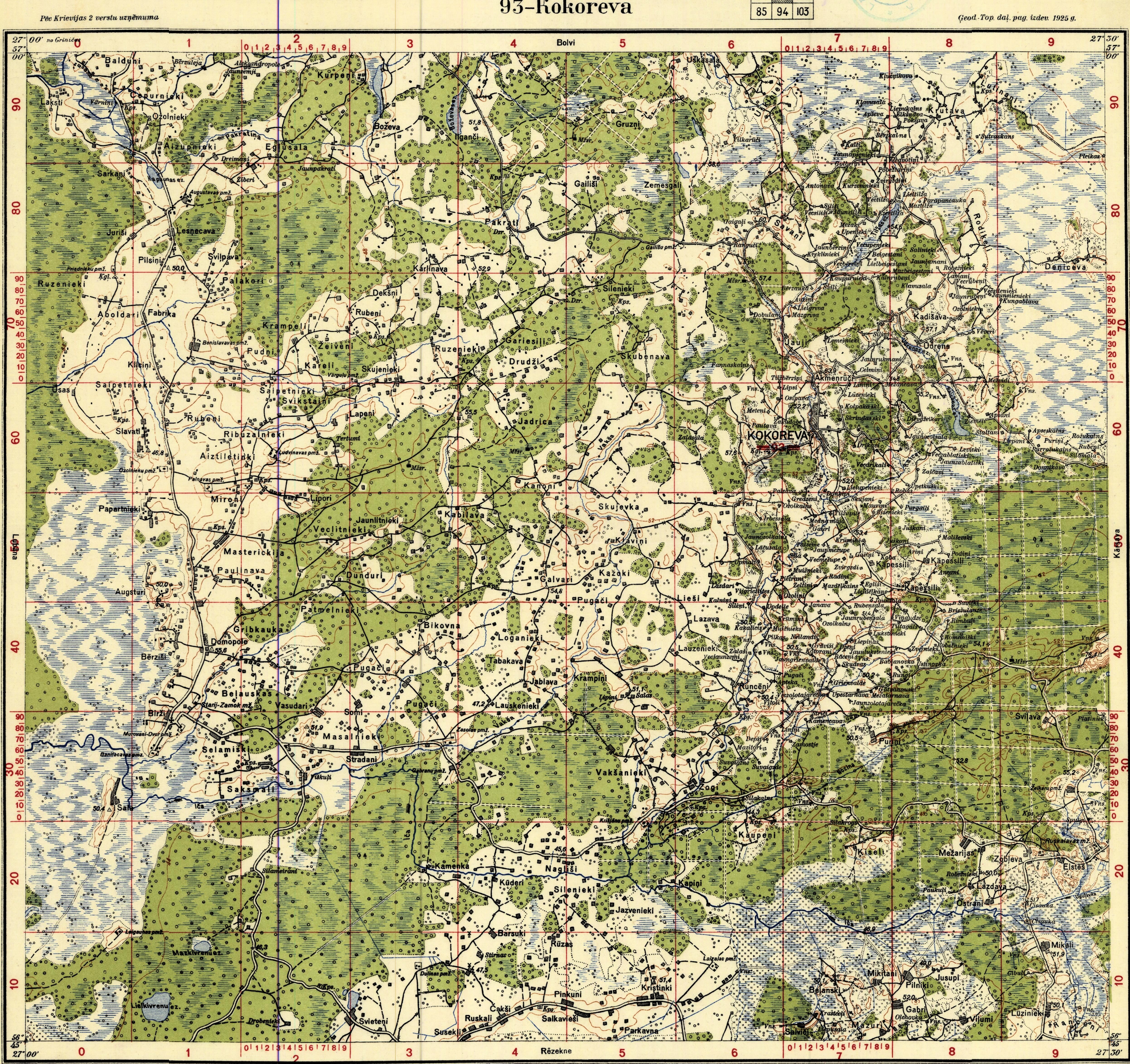
Latvian topographic maps scaled 1:75000 were published 1924-1935 by the Geodesic - Topographic
Division of Latvian army headquarters (Armijas Štāba Ģeodēzijas Topogrāfijas Dala). These maps, which
include parts of Estonia, Russia, Belarus and Lithuania, were updated versions of Russian Empire maps, dating
from as far back as 1880, scaled 1:84000 (Двухверстная карта западного пограничного пространства).
Maps are arranged and numbered according to the index map below. Lithuanian topographic maps from the
same period are arranged directly beneath these maps, in roughly the appropriate geographic position.
003 Uzava 010 Piltene 017 Usma 023 Talsi 028 Engure
004 Pavilosta 011 Kuldiga 018 Kabile 024 Zemite 029 Tukums 032 Sloka 039 Riga 048 Ogre 057 Madliena 066 Ergli 075 Madona 084 Lubana 093 Kokoreva 102 Karsava
035 Ainazi 044 Aloja 053 Rujiena 062 Ergeme 071 Valka
008 Ovisi 015 Dundaga 021 Roja
002 Libciems 009 Ventspils 016 Ugale 022 Valdemarpils 027 Mersrags
042 Vaski 051 Birze 060 Nereta 069 Subata 078 Bebrene 087 Viski 096 Pusa 105 Dagda 111 Polescina


070 Rakiski 079 Ilukste 088 Daugavpils 097 Kraslava 106 Indra
Map legend translation:

080 Ezereni 089 Tarzeki


1939 Jančauskas: "KAUNAS,"
published by Štabo Karo Topografijos
Skyriaus, 1:25 000 From www.mapywig.
com
published by Štabo Karo Topografijos
Skyriaus, 1:25 000 From www.mapywig.
com
