Maps: 1817 - 1825

1819 John Cary:
"POLAND DIVIDED
ACCORDING TO THE
CONGRESS OF
VIENNA," London, 11.5
x 9.5 inches. From
www.raremaps.com.
"POLAND DIVIDED
ACCORDING TO THE
CONGRESS OF
VIENNA," London, 11.5
x 9.5 inches. From
www.raremaps.com.
1818 Lewis Hebert (geographer/draftsman) - Samuel
Neele (engraver) - Thomas Dobson (American publisher):
"POLAND," Philadelphia, 21 x 28 inches / 85 x 59 cm.,
from "Pinkerton’s Modern Atlas."
Neele (engraver) - Thomas Dobson (American publisher):
"POLAND," Philadelphia, 21 x 28 inches / 85 x 59 cm.,
from "Pinkerton’s Modern Atlas."
1819 James Wyld (artist)
- N.R. Hewitt (engraver) -
John Thompson
(publisher): "POLAND,"
Edinburgh, 14 x 10.5
inches / 36 x 27 cm.
Wyld took over Fadden's
business. From
www.alexandremaps.com
- N.R. Hewitt (engraver) -
John Thompson
(publisher): "POLAND,"
Edinburgh, 14 x 10.5
inches / 36 x 27 cm.
Wyld took over Fadden's
business. From
www.alexandremaps.com
1820 Vasilii Petrovich Pyadyshev (Pedischeff, Piadischeff, Piadyshev, Piadishev, Pyatychev: 1768-1835): "Atlas geographique de l'Empire de Russe, du Royaume de Pologne et du Grand
Duche Finlande..." (83 sheets), St. Petersburg, Russian Topographical Depot, 1820-27, 1829, 1834. Below are a number of high-resolution maps, of Russian Guberniyas as of 1820.
Information in Polish and Russian. From wikipedia and easteurotopo.org
Duche Finlande..." (83 sheets), St. Petersburg, Russian Topographical Depot, 1820-27, 1829, 1834. Below are a number of high-resolution maps, of Russian Guberniyas as of 1820.
Information in Polish and Russian. From wikipedia and easteurotopo.org
| Estland - Estonia g. |
| Grodno g. |

| Kurland g. |
| Livonia g. |

| Minsk g. |

| Kingdom of Poland. |

| Pskov g. |

| St. Petersburg g. |
| Vilna g. |

1821 Barlow (engraver):
"POLAND, Shewing the
Claims of RUSSIA,
PRUSSIA and AUSTRIA.
From the best
Authorities," Bungay,
Suffolk, England, 8 x 7
inches / 21 x 17 cm.
Published by C. Brightly
& E. Kennersley. From
eBay 2003
"POLAND, Shewing the
Claims of RUSSIA,
PRUSSIA and AUSTRIA.
From the best
Authorities," Bungay,
Suffolk, England, 8 x 7
inches / 21 x 17 cm.
Published by C. Brightly
& E. Kennersley. From
eBay 2003

1821-24 B. Smith
(engraver) - Alex Macredie
(Publisher): "POLAND
Drawn and Engraved for
Playfair's Atlas," Edin-
burgh, 21 x 17.5 inches.
Playfair invented four
types of diagrams: the line
graph and bar chart of
economic data, the pie
chart and circle graph!
From www.raremaps.com
(engraver) - Alex Macredie
(Publisher): "POLAND
Drawn and Engraved for
Playfair's Atlas," Edin-
burgh, 21 x 17.5 inches.
Playfair invented four
types of diagrams: the line
graph and bar chart of
economic data, the pie
chart and circle graph!
From www.raremaps.com

1824 Aristide Michel
Perrot: "Carte ...de
Napoleon et de la Grande
Armee...," 13.8 x 18.5
inches/ 35.0 x 47.0 cm,
by Comte Philipp-Paul de
Segur, aide-de-camp to
Napoleon, and created to
enable the French public
to follow the Napoleonic
wars. From www.swaen.com
Perrot: "Carte ...de
Napoleon et de la Grande
Armee...," 13.8 x 18.5
inches/ 35.0 x 47.0 cm,
by Comte Philipp-Paul de
Segur, aide-de-camp to
Napoleon, and created to
enable the French public
to follow the Napoleonic
wars. From www.swaen.com

1825 George Ellis: "POLAND,"
Westminster, 27 x 23 cm., from "Ellis's
General Atlas of the World, with the
Latest Discoveries and New Continental
Alterations," published in editions of 1811
and 1825. From www.miklianmaps.com
Westminster, 27 x 23 cm., from "Ellis's
General Atlas of the World, with the
Latest Discoveries and New Continental
Alterations," published in editions of 1811
and 1825. From www.miklianmaps.com


1820 Robert Wilkinson: "POLAND," 13 x 10 inches
/ 33 x 26 cm, from "Wilkinson's General Atlas of
the World," 2nd Edition. Many maps in this
edition are dated back to 1809. Compare this
version of his map of Poland with the 1810 and 1814
versions on the previous page. From Albion Prints.
/ 33 x 26 cm, from "Wilkinson's General Atlas of
the World," 2nd Edition. Many maps in this
edition are dated back to 1809. Compare this
version of his map of Poland with the 1810 and 1814
versions on the previous page. From Albion Prints.
c. 1820 (Anon.): "A.6 [Lithuania/
Poland]," Paris, 19.3 x 30.9 inches / 49
x 78.5 cm, 20-segment folding map
pasted on linen. From www.swaen.com
Poland]," Paris, 19.3 x 30.9 inches / 49
x 78.5 cm, 20-segment folding map
pasted on linen. From www.swaen.com

C. Gros: "GEOGRAPHICAL AND STATISTICAL MAP OF
POLAND AND HUNGARY," published in Philadelphia
for M. Cary & Son, 30 x 33 cm, from "Lavoisine's
Complete Genealogical, Historical and Chronological
Atlas," first published with maps in London by John
Barfield in 1814. Two versions, both based on the 1817
London edition, with corrections and additions: 1820
(from www.davidrumsey.com) and 1821 (from
www.jpmaps.co.uk)


c. 1820 (Anon.) folding map of Central
Europe, Paris, perhaps produced by the
samepublisher as the map to the left.
From cesgia, on eBay
Europe, Paris, perhaps produced by the
samepublisher as the map to the left.
From cesgia, on eBay

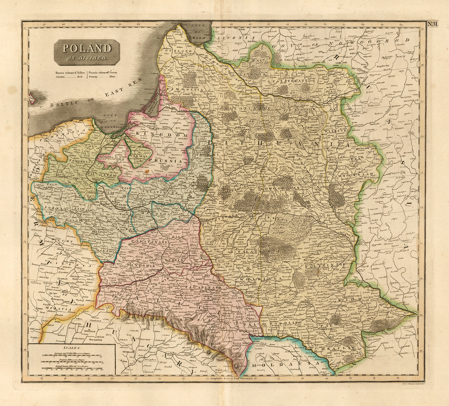
1821 James V. Seaman
(pubisher): "POLAND as
Divided," New York, 19 x
22 cm, from the 26-map
"A new general atlas,
chiefly intended for the
use of schools and private
libraries." From
www.davidrumsey.com
(pubisher): "POLAND as
Divided," New York, 19 x
22 cm, from the 26-map
"A new general atlas,
chiefly intended for the
use of schools and private
libraries." From
www.davidrumsey.com

1825 Philippe Marie Vandermaelen:
"EUROPE No,9. PARTIE DE LA RUSSIE,"
Brussels, 20 x 18 inches. From Vander-
maelen's remarkable six-volume atlas,
which if combined as globe gores, forms an
immense globe. See the 1827 map for
comparison. From www.raremaps.com
"EUROPE No,9. PARTIE DE LA RUSSIE,"
Brussels, 20 x 18 inches. From Vander-
maelen's remarkable six-volume atlas,
which if combined as globe gores, forms an
immense globe. See the 1827 map for
comparison. From www.raremaps.com

1819 Adolf Steiler
(editor) - F. Hase
(engraver): "OSTSEE-
LAENDER von der
Oder bis zur Newa,"
Gotha, 36 x 30 cm,
from his "Hand-Atlas,"
published by Justus
Perthes. From
www.davidrumsey.com
(editor) - F. Hase
(engraver): "OSTSEE-
LAENDER von der
Oder bis zur Newa,"
Gotha, 36 x 30 cm,
from his "Hand-Atlas,"
published by Justus
Perthes. From
www.davidrumsey.com

1821 John Souter (editor)
- T. Tyler (engraver):
"POLAND," London, 8
1/4 x 7 1/4 inches, from
"Clark's New School
Maps." From
antiquemapsandprints on eBay
- T. Tyler (engraver):
"POLAND," London, 8
1/4 x 7 1/4 inches, from
"Clark's New School
Maps." From
antiquemapsandprints on eBay

1818 Robert Wilkinson:
"POLAND," London, 9 x
11 inches, from the 1818
edition of his "General
Atlas of the World"
despite the map's date of
1814. Compare with the
1820 version. From Pacific
Shore Maps: psmaps on eBay
"POLAND," London, 9 x
11 inches, from the 1818
edition of his "General
Atlas of the World"
despite the map's date of
1814. Compare with the
1820 version. From Pacific
Shore Maps: psmaps on eBay


1824 Tranquillo Mollo:
"Polen nach den Letzten
Friedenschlüssen, nebst
den angränzenden Länd-
ern" ("Poland after the
last treaties, and adjacent
countries"), Vienna, from
his "lehrbuch der
Geographie, 2nd Ed., pg
90. From www.bergbook.com
"Polen nach den Letzten
Friedenschlüssen, nebst
den angränzenden Länd-
ern" ("Poland after the
last treaties, and adjacent
countries"), Vienna, from
his "lehrbuch der
Geographie, 2nd Ed., pg
90. From www.bergbook.com

| 1820 |

1818 Mathew Carey:
"POLAND," Philadelphia,
32 x 36 cm., from the
third and last edition of
"Carey's General Atlas,
Improved And Enlarged,"
From www.davidrumsey.com
"POLAND," Philadelphia,
32 x 36 cm., from the
third and last edition of
"Carey's General Atlas,
Improved And Enlarged,"
From www.davidrumsey.com
1817 John & George Menzies (engravers) - John Thomson (publisher): "POLAND, AS
DIVIDED," 19 3/4 x 23 5/8 inches, Edinburgh, "drawn and engraved" for the first
edition of his "New General Atlas," dated 1814 but actually published 1817. See the
first state of this map c. 1815-16
DIVIDED," 19 3/4 x 23 5/8 inches, Edinburgh, "drawn and engraved" for the first
edition of his "New General Atlas," dated 1814 but actually published 1817. See the
first state of this map c. 1815-16


1823 Dite De Crozat:
"Pologne," Paris, 6 x 6.75
inches, from his "Géo-
graphie Universelle."
From www.jpmaps.co.uk
"Pologne," Paris, 6 x 6.75
inches, from his "Géo-
graphie Universelle."
From www.jpmaps.co.uk

| Vitebsk g. |

| Mogilevskoi g. |
1817 [dated] Charles Francois
Delamarche - Robert de Vaugondy:
"Nouveau Royaume de Pologne..."
Paris, 19.1 x 24.0 inches, showing
pre-Partition and Congress of
Vienna boundaries. See the 1807
version of this map, with Treaties
of Tilsit boundaries. From Univ. of
Virginia Library:
http://search.lib.virginia.edu/
Delamarche - Robert de Vaugondy:
"Nouveau Royaume de Pologne..."
Paris, 19.1 x 24.0 inches, showing
pre-Partition and Congress of
Vienna boundaries. See the 1807
version of this map, with Treaties
of Tilsit boundaries. From Univ. of
Virginia Library:
http://search.lib.virginia.edu/


| lindisfarne Prints on eBay |
| www.davidrumsey.com |

1824 [dated 1823] Aristide Michel Perrot
(geographer/mapmaker) - Madame Adrien
Migneret (engraver) : ""POLOGNE," Paris,
5.5 x 4.5 inches, steelplate from "la
Geographie par Thierry." Note engraved
wild boar, behive, oak leaves, sword, etc.,
as well as two national heroes: Sobieski
and Kosciusko. From www.raremaps.com
(geographer/mapmaker) - Madame Adrien
Migneret (engraver) : ""POLOGNE," Paris,
5.5 x 4.5 inches, steelplate from "la
Geographie par Thierry." Note engraved
wild boar, behive, oak leaves, sword, etc.,
as well as two national heroes: Sobieski
and Kosciusko. From www.raremaps.com

1817 [dated] Bartolomeo
Borghi (engraver/
cartographer): "Come fu e
come trovasidivisa al
presente la Polonia,"
Florence, 23.5 x 32 cm,
from "Atlante generale."
From www.libreriaperini.com
Borghi (engraver/
cartographer): "Come fu e
come trovasidivisa al
presente la Polonia,"
Florence, 23.5 x 32 cm,
from "Atlante generale."
From www.libreriaperini.com

1819 [dated] John Cary
(engraver/mapseller) -
William Faden (publisher):
"A New Map of Poland and
the Grand Duchy of
Lithuania..," London, 54
x 60 cm, based on Rizzi-
Zannoni's 1772 24-sheet
map. From Harvard Map
Library:https://library.harvard.
edu/map
(engraver/mapseller) -
William Faden (publisher):
"A New Map of Poland and
the Grand Duchy of
Lithuania..," London, 54
x 60 cm, based on Rizzi-
Zannoni's 1772 24-sheet
map. From Harvard Map
Library:https://library.harvard.
edu/map

1823 Fielding Lucas Jr. (engraver/
cartographer/publisher): "POLAND,"
Baltimore, 12 x 8.5 inches, from "A
General Atlas Containing Distinct Maps Of
all the known Countries in the World."
Note "New East Prussia," "Kingdom of
Poland," and "Lithuania, labeled over New
East Prussia. From www.raremaps.com
cartographer/publisher): "POLAND,"
Baltimore, 12 x 8.5 inches, from "A
General Atlas Containing Distinct Maps Of
all the known Countries in the World."
Note "New East Prussia," "Kingdom of
Poland," and "Lithuania, labeled over New
East Prussia. From www.raremaps.com

1822 Friedrich Haller von Hallerstein
(geographer/cartographer) - Friedrich
Campe (publisher): "Charte vom Konig-
reich Preussen und Polen," Nurnberg, 25 x
29 cm, from "Neuer Hand-Atlas uber alle
Theile der Erde..." From
www.davidrumsey.com
(geographer/cartographer) - Friedrich
Campe (publisher): "Charte vom Konig-
reich Preussen und Polen," Nurnberg, 25 x
29 cm, from "Neuer Hand-Atlas uber alle
Theile der Erde..." From
www.davidrumsey.com

1825 Gerard Lemaitre
(engraver): "Carte
Générale de la Pologne,"
Paris, 21.6 x 20.1 cm.
Reproduced in 1840 and
1879, crediting Theodore
Delsol -- born 1819, as
the engraver. From cesgia
on eBay
(engraver): "Carte
Générale de la Pologne,"
Paris, 21.6 x 20.1 cm.
Reproduced in 1840 and
1879, crediting Theodore
Delsol -- born 1819, as
the engraver. From cesgia
on eBay


1818 William Guthrie (geographer/publisher) : "Poland
from the Best Authorities," London, image 8.25 x 7
inches, in two examples from "An Atlas to Guthrie"s
Geographical Grammar."
from the Best Authorities," London, image 8.25 x 7
inches, in two examples from "An Atlas to Guthrie"s
Geographical Grammar."
| firefreak54 on eBay |
| www.antique-maps-online.co.uk |
| 1821 |

1817 [dated] Carl
Kretschmer (artist/
mapmaker): "Karte von
Kurland." From the State
Archives in Poznan, Poland:
www.piasa.org/
archivesinpoland via
www.mapywig.org
Kretschmer (artist/
mapmaker): "Karte von
Kurland." From the State
Archives in Poznan, Poland:
www.piasa.org/
archivesinpoland via
www.mapywig.org
| www.geographicus.com |

| University of Wisconsin, Milwaukee, Libraries: https://collections. lib.uwm.edu/ |

c. 1823 James Wyld (geographer/
engraver): "A Map of the Kingdom of
Poland, Describing its Ancient Limits with
the Dismemberments; Likewise its Present
Boundary as Settled by Act of Congress at
Vienna..," London, 23.5 x 21 inches.
originally published with a different title
by William Faden in 1799, which itself
was based on Rizzi-Zannoni's 24-sheet map
of 1772. See the dated 1838 and 1843
versions. From www.raremaps.com
| www.raremaps.com |

1820 Luigi Rossi (historian) - Giuseppe
Canini (engraver) - Carlo Antonio
Barbiellini (publisher): "La Polonia colle
Divisioni..," Milan, from "Nuovo atlante di
geografia universale." From www.swaen.com
Canini (engraver) - Carlo Antonio
Barbiellini (publisher): "La Polonia colle
Divisioni..," Milan, from "Nuovo atlante di
geografia universale." From www.swaen.com

c. 1820 Johann Dreyer (mapmaker):
"KARTE von KURLAND," Mitau, 35 x 26
cm. From Münster Univ.- und Landesbibliothek,
Map Collection August von Haxthausen:
https://sammlungen.ulb. uni-muenster.de/
"KARTE von KURLAND," Mitau, 35 x 26
cm. From Münster Univ.- und Landesbibliothek,
Map Collection August von Haxthausen:
https://sammlungen.ulb. uni-muenster.de/