Maps: 1922 - 1939
Mapmakers try to keep up with what they think
are Lithuania's boundaries, as Poland hopes for a
reunited Polish-Lithuanian Commonwealth
are Lithuania's boundaries, as Poland hopes for a
reunited Polish-Lithuanian Commonwealth
1922 [dated] Instytutu
Wojskowo Geograficznego
(mapmaker): "RZECZ-
POSPOLITA POLSKA I
KRAJE OSCIENNE"
(Republic of Poland and
Neighboring Lands),
Warsaw. From www.
mapywig.org
Wojskowo Geograficznego
(mapmaker): "RZECZ-
POSPOLITA POLSKA I
KRAJE OSCIENNE"
(Republic of Poland and
Neighboring Lands),
Warsaw. From www.
mapywig.org
1922 C.S. Hammond:
"Baltic States & East
Prussia," from "The
Times Survey Atlas,"
London, created by
John Batholomew
Ltd. (AK)
"Baltic States & East
Prussia," from "The
Times Survey Atlas,"
London, created by
John Batholomew
Ltd. (AK)

1922 "POLAND."
From a U.S. atlas.
(AK)
From a U.S. atlas.
(AK)
C.S. Hammond: "The Baltic States.
ESTHONIA, LATVIA, LITHUANIA."
Grodno, Lida, Vilna and Vidzy are in Lith-
uania in the '23, but not the '27 map.
ESTHONIA, LATVIA, LITHUANIA."
Grodno, Lida, Vilna and Vidzy are in Lith-
uania in the '23, but not the '27 map.

1927-28
"Dunlop
Automobil
Strassen-
karte von
Deutschland,"
Ravenstein
Atlas plates.
From www.
kartenmeister.com
"Dunlop
Automobil
Strassen-
karte von
Deutschland,"
Ravenstein
Atlas plates.
From www.
kartenmeister.com
| 1927-28 "Tilsit. 1" |

| 1927-28 "Kowno 2." |

| 1927-28 "Suwalki 8." |

| 1927-28 "Augustowo. 18" |


1922 "LITHUANIA," from
the Probert (Online)
Encyclopedia:http://
www.probertencyclopaedia.com/
the Probert (Online)
Encyclopedia:http://
www.probertencyclopaedia.com/
1922 "POLAND." from the
Probert (Online) Encyclopedia
Probert (Online) Encyclopedia


Interwar
Years: "LETT-
LAND" postcard
map.
From eBay auction
Years: "LETT-
LAND" postcard
map.
From eBay auction
1923 W. Johnston:
"THE BALTIC PROV-
INCES" 5" x 7". From
periodpaper, eBay
"THE BALTIC PROV-
INCES" 5" x 7". From
periodpaper, eBay


c. 1930 London
Geographical Inst.:
"POLAND, with the free
territory OF DANZIG,
EAST PRUSSIA and
LITHUANIA," London, 27 x
22 inches, at 1:500 000.
A folded, linen-backed,
map published by George
Philip & Son, Ltd. Also a
DETAIL map of Lithuania.
(AK) Note the southern
boundary of Lithuania,
which incorrectly follows
too many river courses.


1928 "Polen, Baltische Rand-
staaten," Leipzig, 16.5 x 13.5
inches, from the "Minerva
Atlas." From
www.montrealmaps.com
staaten," Leipzig, 16.5 x 13.5
inches, from the "Minerva
Atlas." From
www.montrealmaps.com

1930 "Polen,"
from a German
atlas. From eBay
from a German
atlas. From eBay


1930 Steilers Handatlas:
"Estland - Lettland - Litauen,"
13.25 x 16.5 inches.
1:1500000. Published by
Gotha: Justus Perthes. (AK)
"Estland - Lettland - Litauen,"
13.25 x 16.5 inches.
1:1500000. Published by
Gotha: Justus Perthes. (AK)
1932 Probert (Online)
Encyclopedia:
"LITHUANIA"
Encyclopedia:
"LITHUANIA"
1932 Knauers
Atlas: "Polen..." (AK)
Atlas: "Polen..." (AK)
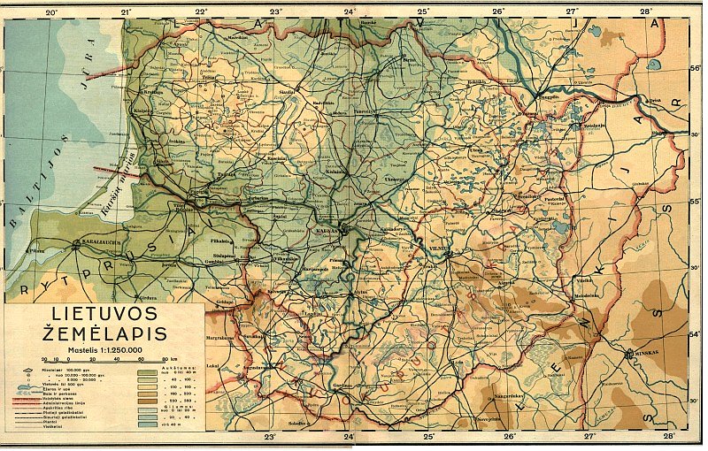
1935 Spindulio Lit.: "LIETUVOS ZEMELAPIS," Kaunas,
in two differently-colored versions.
in two differently-colored versions.
1938 W. Cukrynski:
"REPUBLIKA LITEWSKA"
From www.mapywig.org
"REPUBLIKA LITEWSKA"
From www.mapywig.org
1938 Probert (Online)
Encyclopedia:
"LITHUANIA"
Encyclopedia:
"LITHUANIA"


1938 "LIETUVOS
ŽEMĖLAPIS," showing
eastern Lithuania as
occupied by Poland. From
www.karty.by
ŽEMĖLAPIS," showing
eastern Lithuania as
occupied by Poland. From
www.karty.by

1936 Jozef Zawadzki:
"MAPA DROGOWA i
TURYSTYCZNA WOJE-
WODZTWA WILEN-
SKIEGO." (Road and
Tourism Map of the Wilno
Region) 1: 300 000.
From www.karty,by
"MAPA DROGOWA i
TURYSTYCZNA WOJE-
WODZTWA WILEN-
SKIEGO." (Road and
Tourism Map of the Wilno
Region) 1: 300 000.
From www.karty,by

1936 Privately-
produced "patriotic"
envelope map showing
"occupied" Lithuania.
From an eBay auction
produced "patriotic"
envelope map showing
"occupied" Lithuania.
From an eBay auction

1931 Railway map.

1923 The Geographical
Publishing Co: " RZECZ-
POSPOLITA POLSKA," at
1:1 000 000. From
www.karty.by
Publishing Co: " RZECZ-
POSPOLITA POLSKA," at
1:1 000 000. From
www.karty.by


1938 "Baltische Staaten," in both a relief map, and
one showing German populations, with four
DETAIL images. From www.montrealmaps.com
one showing German populations, with four
DETAIL images. From www.montrealmaps.com


1938 A. Braks: "Klapėda" and "Tilžė"
published in Kaunas as "Lietuvos
Praeities Vaizdai" by Dr. J. Remeika
(AK)
published in Kaunas as "Lietuvos
Praeities Vaizdai" by Dr. J. Remeika
(AK)

1938 C.S. Ham-
mond & Co.:
"POLAND." From
http://maps.
vlasenko.net/
mond & Co.:
"POLAND." From
http://maps.
vlasenko.net/


1939 Bibliographischen Institut AG, Leip-
zig: "MILITÄRGEOGRAPHISCHE KARTE
VON LITAUEN, UND DEM MEMELGEBIET"
at 1:400 000, from early that year, before
the invasion of Poland by Germany, and
before the occupation of Lithuania by
Soviet forces. From http://english.mapywig.org/
zig: "MILITÄRGEOGRAPHISCHE KARTE
VON LITAUEN, UND DEM MEMELGEBIET"
at 1:400 000, from early that year, before
the invasion of Poland by Germany, and
before the occupation of Lithuania by
Soviet forces. From http://english.mapywig.org/

1922 W. Glo czewski:
"SPECIJALNA MAPA
KOLEJOWA POLSKI"
(Polish Rail Map). From
www.mapywig.org
"SPECIJALNA MAPA
KOLEJOWA POLSKI"
(Polish Rail Map). From
www.mapywig.org


1926 E. Romer - J.
Wasowicz: "RZECZ-
POSPOLITA POLSKA
MAPA POLITYCZNA."
From www.mapywig.org
Wasowicz: "RZECZ-
POSPOLITA POLSKA
MAPA POLITYCZNA."
From www.mapywig.org

1939, September 12: "KARTE
VON POLEN," a promotional
offprint of a map that appeared
in the Munich newspaper
Völkischen Beobachter (People's
Observer). The tag line is
"Millions red the V.B....and You?"
Shows what appears to be the
front lines in Poland. From
www.mapywig.org
VON POLEN," a promotional
offprint of a map that appeared
in the Munich newspaper
Völkischen Beobachter (People's
Observer). The tag line is
"Millions red the V.B....and You?"
Shows what appears to be the
front lines in Poland. From
www.mapywig.org

1923 Fr. Karpowicz:
"(Poland and neigh-
boring countries),
Warsaw, 1: 1 500 000.
From www.mapywig.org
"(Poland and neigh-
boring countries),
Warsaw, 1: 1 500 000.
From www.mapywig.org


1928 Feliksa Dabrowski-
ego - Edwarda Nowickiego:
"Mapa Wojewodztwa
Wilenskiego," Wilno, at
1:300 000. From
www.mapywig.org
ego - Edwarda Nowickiego:
"Mapa Wojewodztwa
Wilenskiego," Wilno, at
1:300 000. From
www.mapywig.org

1925 Pokorny - Adam
Tomaszewski: "MAPA
POLSKI," Lwow. From
www.mapywig.org
Tomaszewski: "MAPA
POLSKI," Lwow. From
www.mapywig.org
1922 "Baltische Länder,"
Leipzig, from "Allgemeiner
Handatlas." From www.
montrealmaps.com
Leipzig, from "Allgemeiner
Handatlas." From www.
montrealmaps.com

1939 "Politische Gliederung Bevoelkerung-
sdichte und Nationalitaetenverteilung in
Litauen" (Political Structure, population
density and distribution by nationality in
Lithuania), at 1:750 000, based on a 1923
census in Lithuania, and a 1938 census in
the Memelland. Published by the German
Department for War Maps and Surveying.
From www.mapywig.org

c. 1939 Eugeniusz Romer and T.
Szumanski: "Polska Północna" (Northern
Poland), Lwów, a physical map, at 1:2 500
000, of nothern Poland, East Prussia,
Lithuania, and southern Latvia. From
mykrak.com
Szumanski: "Polska Północna" (Northern
Poland), Lwów, a physical map, at 1:2 500
000, of nothern Poland, East Prussia,
Lithuania, and southern Latvia. From
mykrak.com


1939 Steilers Hand- atlas:
"Westrussland," Gotha, 15 x 19
inches, 1:3700000, published by
Justus Perthes. Also two DETAIL
images. (AK)
"Westrussland," Gotha, 15 x 19
inches, 1:3700000, published by
Justus Perthes. Also two DETAIL
images. (AK)

1929 K. Stefczyk: "LITWA Schemat linij
komunika- cyjnych sieci wodnej i zalesienia"
(Map of lines of communication, water and
forest cover), in two images, as published in
"Lithuania, military- geographical and statistical
overview," in the military periodical "Bellona,"
named for the Roman Goddess of War, sister of
Mars. From www.mapywig.org

1925 Adolph Stieler:
“Estland - Lettland –
Litauen,” Gotha, from
his "Hand-Atlas." From
www.davidrumsey.com
“Estland - Lettland –
Litauen,” Gotha, from
his "Hand-Atlas." From
www.davidrumsey.com

1928 Private
postcard map:
"Lietuva." From
David Delahaye,
Philadelphia
postcard map:
"Lietuva." From
David Delahaye,
Philadelphia
1934 "POLAND," New York,
from "Atlas of the World", C.
S. Hammond & Co., with
unusual boundaries for
Lithuania. From
montrealmaps.com
from "Atlas of the World", C.
S. Hammond & Co., with
unusual boundaries for
Lithuania. From
montrealmaps.com

1939 "Rzeczpospolita POLSKO-
LITEWSKA - Taka musi
byc nasza Rzeczpospolita" "LEN-
KIJOS-LIETUVOS Respublika -
Tokia turi būti mūsu Respubl-
ika," Lwow. A propaganda map
for sale in Poland as WWII drew
near. From www.mapywig.org
LITEWSKA - Taka musi
byc nasza Rzeczpospolita" "LEN-
KIJOS-LIETUVOS Respublika -
Tokia turi būti mūsu Respubl-
ika," Lwow. A propaganda map
for sale in Poland as WWII drew
near. From www.mapywig.org

1939 (Anon.): "POLEN,"
a classified German
military map with all
Polish towns in Polish,
Lithuanian towns in
Lithuanian and Polish,
updated with new,
April 4, 1938, borders
for Czechoslovakia.
From
www.easteurotopo.org
a classified German
military map with all
Polish towns in Polish,
Lithuanian towns in
Lithuanian and Polish,
updated with new,
April 4, 1938, borders
for Czechoslovakia.
From
www.easteurotopo.org

1926 "Mapa Wojew. Wilenskiego," Vilnius, at
1:300 000, published by Regional
Directorate of Public Works, Vilnius. From
www.polona.pl
1:300 000, published by Regional
Directorate of Public Works, Vilnius. From
www.polona.pl


1939 Antonio F. Raggio: "Estonia," and "Lituania," Buenos
Aires, an award-winning pair of 12 x 8 inch manuscript
cards prepared for the 11th Congreso de la Union Postal
Universal (World Postal Congress) Exposition Filatelica
Internacional, held in Buenos Aires, Argentina in 1939.
The award was given to Raggio by La Sociedad Filatelica
Argentina for a collection of maps on cards dawn by
Raggio for the event, the majority of which consisted of a
map and companion illustrated fact sheet. Commentary and
images from www.raremaps.com
1930 "Lietuvos Zemelapis"
as a physical map, in two
images. From eBay
as a physical map, in two
images. From eBay

1939 "Litauen," Antwerp, 8.5 x 13 inches
/ 24 x33 cm, published by Uitgegeven
Door De Dag for W.Seghers and Van
Limbergen's "Patrias Wereldatlas." The
map shows a very interesting reduced
"Wilno" area. From makamae3332 on eBay
/ 24 x33 cm, published by Uitgegeven
Door De Dag for W.Seghers and Van
Limbergen's "Patrias Wereldatlas." The
map shows a very interesting reduced
"Wilno" area. From makamae3332 on eBay

1925 Geographical
Publishing Co.:
"Poland," Toronto,
Cummins Map Co.
From www.david
rumsey.com
Publishing Co.:
"Poland," Toronto,
Cummins Map Co.
From www.david
rumsey.com


1928 Povilas Matulionis:
"Lietuvos žemėlapis," at 1:
800 000, showing Riga
Treaty boundaries, and
claimed boundaries, and
forests! From The
Wroblewski Library of the
Lithuanian Academy of
Sciences: elibrary.mab.lt/
"Lietuvos žemėlapis," at 1:
800 000, showing Riga
Treaty boundaries, and
claimed boundaries, and
forests! From The
Wroblewski Library of the
Lithuanian Academy of
Sciences: elibrary.mab.lt/
1924 "Mapa
Drozni...
Wschodniej
Polski" (Roads of
NE Poland) From
www.mapywig.org
Drozni...
Wschodniej
Polski" (Roads of
NE Poland) From
www.mapywig.org

c. 1930 (Anon.): "Lietuvos
miškų žemėlapis," Kaunas.
From The Wroblewski Library
of the Lithuanian Academy of
Sciences: elibrary.mab.lt/
miškų žemėlapis," Kaunas.
From The Wroblewski Library
of the Lithuanian Academy of
Sciences: elibrary.mab.lt/

1926 "Norden," Stockholm, from
"Nordisk Vaerldsatlas," showing
"Litauen" with a dotted- line border
with "Polen." From
www.montrealmaps.com
"Nordisk Vaerldsatlas," showing
"Litauen" with a dotted- line border
with "Polen." From
www.montrealmaps.com

1922 Paštų telegr. ir
telefon. valdyba:
"Lietuvos paštų sekimo
žemlapis," Kaunas. From
The Wroblewski Library of the
Lithuanian Academy of
Sciences: elibrary.mab.lt/
telefon. valdyba:
"Lietuvos paštų sekimo
žemlapis," Kaunas. From
The Wroblewski Library of the
Lithuanian Academy of
Sciences: elibrary.mab.lt/


1926 Riigi statistika
keskbüroo väljaanne
(National Central Bureau
of Statistics publications):
"Eesti," Talinn. From
wikimedia
keskbüroo väljaanne
(National Central Bureau
of Statistics publications):
"Eesti," Talinn. From
wikimedia

1922 Bartholomew -
Times Atlas of the
World (publisher):
Eastern Europe..,"
London. From
www.davidrumsey.com
Times Atlas of the
World (publisher):
Eastern Europe..,"
London. From
www.davidrumsey.com
| 1923 AK |
| c. 1927 Vintage Art Maps and Prints on eBay |
| AK |
1930 E. Romer:
"Województwo
Wileńskie i Nowo-
gródzkie."From
www.mapywig.org
"Województwo
Wileńskie i Nowo-
gródzkie."From
www.mapywig.org
Germans preparing to invade Poland on
September 1, 1939
September 1, 1939

1939 "Politico Administrativnaya Karta
Belorusskoy SSR," at 1:500 000, from the
"Bolshoi-Sovetsky Atlas of the World."
Belorusskoy SSR," at 1:500 000, from the
"Bolshoi-Sovetsky Atlas of the World."


c. 1938 "Mapa dróg wodnych
Rzeczypos- politej Polskiej z podziałem
admini- stracyjnym" (Map of
Waterways of the Republic of Poland...),
Warsaw, 38 x 34 inches. From www.
raremaps.com
Rzeczypos- politej Polskiej z podziałem
admini- stracyjnym" (Map of
Waterways of the Republic of Poland...),
Warsaw, 38 x 34 inches. From www.
raremaps.com

1939 Abteilung für Kriegskarten und
Vermeßungswesen (Dept. of War Maps
and Surveys) (publisher): "POLEN," at 1: 1
000 000, depicting most of Lithuania
and northern Czechoslovakia, with
boundary lines between Poland and
Czechoslovakia for Dec. 10, 1938, and
April 4, 1939. From www.mapywig.org
Vermeßungswesen (Dept. of War Maps
and Surveys) (publisher): "POLEN," at 1: 1
000 000, depicting most of Lithuania
and northern Czechoslovakia, with
boundary lines between Poland and
Czechoslovakia for Dec. 10, 1938, and
April 4, 1939. From www.mapywig.org

1923 Carl Flem-
ming: "Die Neuen
Staatenbildungen
im Osten..." up-
dating map Nr. 17
from 1917. From
Staatsbibliothek zu
Berlin via wikimedia
ming: "Die Neuen
Staatenbildungen
im Osten..." up-
dating map Nr. 17
from 1917. From
Staatsbibliothek zu
Berlin via wikimedia

1925 Dr. H. Haack (atlas
editor) - Justes Perthes
(publisher): "Westrußland,"
Gotha, 39 x 42 cm, from
"Stieler's Atlas of Modern
Geography, Tenth (Cen-
tenary) Edition." From
www.davidrumsey.com
editor) - Justes Perthes
(publisher): "Westrußland,"
Gotha, 39 x 42 cm, from
"Stieler's Atlas of Modern
Geography, Tenth (Cen-
tenary) Edition." From
www.davidrumsey.com
1928 Verlag für Börsen-
und Finanz- literatur
Aktiengesellschaft
(publisher): "Schweden
Randstaaten (Estland-
Lettland-Litauen)",
Berlin and Leipzig,
from the third edition
of "Grosser luftver-
kehrs-atlas von
Europa..," a detailed
inter-war reference
book for European
airports. From
www.davidrumsey.com
und Finanz- literatur
Aktiengesellschaft
(publisher): "Schweden
Randstaaten (Estland-
Lettland-Litauen)",
Berlin and Leipzig,
from the third edition
of "Grosser luftver-
kehrs-atlas von
Europa..," a detailed
inter-war reference
book for European
airports. From
www.davidrumsey.com


1922 [dated] General-
nego komisarjatu wy-
borczego (General Elec-
tion Commission: "Mapa
Ilvstracją Frekwencję
Wyborczą" (Map illus-
trating election voting).
From www.elibrary.mab.lt/
nego komisarjatu wy-
borczego (General Elec-
tion Commission: "Mapa
Ilvstracją Frekwencję
Wyborczą" (Map illus-
trating election voting).
From www.elibrary.mab.lt/

1938 [dated] Tadeusz Lipski and Eliasz
Kanarek (designers/illustrators) - Polish
Central Board of State Forests (publisher):
"Poloniӕ," Warsaw, 57 x 73.5 cm. Created
to be distributed for free at the 1939 New
York World's Fair, it was withdrawn
because of imagery offensive to Russia and
Nazi Germany. From www.davidrumsey
Kanarek (designers/illustrators) - Polish
Central Board of State Forests (publisher):
"Poloniӕ," Warsaw, 57 x 73.5 cm. Created
to be distributed for free at the 1939 New
York World's Fair, it was withdrawn
because of imagery offensive to Russia and
Nazi Germany. From www.davidrumsey
c. 1930 Cram:
POLAND,
LITHUANIA,
LATVIA,
ESTONIA and
FREE STATE
OF DANZIG,"
14 x 10.25
inches, Indian-
apolis. From
antiquemapsprints
on eBay
POLAND,
LITHUANIA,
LATVIA,
ESTONIA and
FREE STATE
OF DANZIG,"
14 x 10.25
inches, Indian-
apolis. From
antiquemapsprints
on eBay


1938 (original USSR-produced maps in Leningrad) copied -- in Cyrillic -- and
published 1943 in Washington, D.C., by the U.S. Army Map Service.
Inscribed "First Edition, AMS. For use by War and Navy Department Agencies
only. Not for sale or distribution." Also "Note: Officers using this map will
mark hereon corrections and additions which come to their attention and
mail drect to The Chief of Engineers, Washington, DC.." From www.mapwig.org
| "European Russia Sheet 5" |
| "European Russia Sheet 9" |


1922 [dated]
Eugeniusz Romer:
"Mapa Polski,"
Lwow, a bathy-
metric/topographic
map from most of
Latvia south. From
www.mapywig.org
Eugeniusz Romer:
"Mapa Polski,"
Lwow, a bathy-
metric/topographic
map from most of
Latvia south. From
www.mapywig.org


c. 1922-25 Stanisław
Korbel (geographer/car-
tographer) - Ludomir
Sawicki (geographer/
publisher): "Polska,"
Kraków, from their "Atlas
Geograficzny," published
in five editions between
1922 and 1936. From
www.mapywig.org
Korbel (geographer/car-
tographer) - Ludomir
Sawicki (geographer/
publisher): "Polska,"
Kraków, from their "Atlas
Geograficzny," published
in five editions between
1922 and 1936. From
www.mapywig.org

c. 1925 Peeter Mant-
nieka (cartographer/
publisher): " Liepāja-
Kuldīga," Riga, as
published by his Karto-
grafijas Instituts in
"Tūristu Karte." From
www.mapywig.org
nieka (cartographer/
publisher): " Liepāja-
Kuldīga," Riga, as
published by his Karto-
grafijas Instituts in
"Tūristu Karte." From
www.mapywig.org


1928 Baltischer Verlag (map-
maker) - Amerikanu Petrolejas
Kompanija (publisher): "Latvijas
Satiksmes Ceļu Karte 1,2, 3, 4," Riga.
From www. mapywig.org
maker) - Amerikanu Petrolejas
Kompanija (publisher): "Latvijas
Satiksmes Ceļu Karte 1,2, 3, 4," Riga.
From www. mapywig.org

c. 1922 Adam
Tomaszewski (mapmaker) -
Księgarni Polskiej B.
Połonieckiego (publisher):
"Mała szkolna mapa Polski"
(Small school map of
Poland) Lwów. From
Repozytorium Cyfrowe
Instytutów Naukowych via
www.mapywig.org
Tomaszewski (mapmaker) -
Księgarni Polskiej B.
Połonieckiego (publisher):
"Mała szkolna mapa Polski"
(Small school map of
Poland) Lwów. From
Repozytorium Cyfrowe
Instytutów Naukowych via
www.mapywig.org

1938 [dated] "EESTI JA
TEISED LÄÄNEMERE
KAGUPOOLSED MAAD"
(Estonia and other countries
southeast of the Baltic Sea),
Tallinn. From
www.mapywig.org
TEISED LÄÄNEMERE
KAGUPOOLSED MAAD"
(Estonia and other countries
southeast of the Baltic Sea),
Tallinn. From
www.mapywig.org

1929 "Verkehrskarte von
Litauen mit Entfernun-
gen" (Traffice/road map
of Lithuania, with
distances), with an inset
map of Kaunas, state and
war boundaries, and
"Poland-occupied Lith-
uania." From University of
Wisconsin, Milwaukee, Libraries:
www.collections.lib.uwm.edu/
Litauen mit Entfernun-
gen" (Traffice/road map
of Lithuania, with
distances), with an inset
map of Kaunas, state and
war boundaries, and
"Poland-occupied Lith-
uania." From University of
Wisconsin, Milwaukee, Libraries:
www.collections.lib.uwm.edu/

1930 [dated] Eugeniusz
Romer - Książnica-Atlas
(publisher): "Polska,"
Lwów (Lviv), Warsazwa,
26 x 32 cm. relief map.
From Univ. of Wisconsin,
Milwaukee, Libraries: https:
//collections.lib.uwm.edu/
Romer - Książnica-Atlas
(publisher): "Polska,"
Lwów (Lviv), Warsazwa,
26 x 32 cm. relief map.
From Univ. of Wisconsin,
Milwaukee, Libraries: https:
//collections.lib.uwm.edu/

c. 1939 Jugendherberge (German Youth
Hostel Association (publisher) "Wander-
karte von der Kurischen Nehrung" (Hiking
map of the Curonian Spit), Königsberg
(today's Kaliningrad), with an overprinted
boundary between "Ostpreußen" and
"Litauen (Memelland," as well as a poorly
blocked inset map label showing "Litauen"
included the Memelland. This map was
probably published just before Germany's
annexation of the Memelland in March
1939. From www.mapywig.org

1931 Eugeniusz Romer:
"Mapa Wysokości Względ-
nych w Polsce" (Relative
Elevation), Lwowie. From
www.mapywig.org
"Mapa Wysokości Względ-
nych w Polsce" (Relative
Elevation), Lwowie. From
www.mapywig.org
c. 1925 A. Oschin and
Peeter Mantnieka (carto-
graphers) - Kartografijas
Instituts (publisher):
"LETTONIE," Riga. From
Cartographic and Geological
Institute of Catalonia:
https://cartotecadigital.icgc.
cat/digital/collection
Peeter Mantnieka (carto-
graphers) - Kartografijas
Instituts (publisher):
"LETTONIE," Riga. From
Cartographic and Geological
Institute of Catalonia:
https://cartotecadigital.icgc.
cat/digital/collection


1937 A. Švedrēvics, A. Mednis (map-
makers): "Apceļo savu dzimto zemi" (Travel
around your homeland), Riga. From www.
mapywig.org
makers): "Apceļo savu dzimto zemi" (Travel
around your homeland), Riga. From www.
mapywig.org
1925 [dated] W.I.G.
(mapmaker/publisher):
" MAPA LITWY," with
elevation. From www.
polona.pl via www.
mapywig.org
(mapmaker/publisher):
" MAPA LITWY," with
elevation. From www.
polona.pl via www.
mapywig.org


1927 [dated] Sławomir Miklaszewski
(soil scientist/mapmaker): "Mapa Gleb
Litwy" (Soil Map of Lithuania), Wawsaw,
presented at the 1927 World Congress
of Soil Science, Washington, DC. From
www.soil.isric@wur.nl
(soil scientist/mapmaker): "Mapa Gleb
Litwy" (Soil Map of Lithuania), Wawsaw,
presented at the 1927 World Congress
of Soil Science, Washington, DC. From
www.soil.isric@wur.nl
1934 London
Geographical
Institute:
"Estonia,
Latvia and
Lithuania,"
London, pub-
lished by
George Philip
& Son Ltd.
Lithuanian
are now
primary, with
others in
parens. From
**york** on eBay
Geographical
Institute:
"Estonia,
Latvia and
Lithuania,"
London, pub-
lished by
George Philip
& Son Ltd.
Lithuanian
are now
primary, with
others in
parens. From
**york** on eBay

c. 1934 Czesław
Kuźniar (geologist/
author): "Carte
géolo- gique de la
République
Polonaise," Lwów.
From l'Université
Bordeaux Montaigne:
http://1886.u-bordeaux-
montaigne.fr
Kuźniar (geologist/
author): "Carte
géolo- gique de la
République
Polonaise," Lwów.
From l'Université
Bordeaux Montaigne:
http://1886.u-bordeaux-
montaigne.fr
1935 "Latvijas Karte ar
attālumiem kilometros uz
šosejām un lielceļiem un
pilnīgu vietu vārdu
sarakstu" (Map of Latvia
with distances in
kilometers on roads and
highways and a complete
list of place names) Univ. of
Chicago via www.mapywig.org
attālumiem kilometros uz
šosejām un lielceļiem un
pilnīgu vietu vārdu
sarakstu" (Map of Latvia
with distances in
kilometers on roads and
highways and a complete
list of place names) Univ. of
Chicago via www.mapywig.org

1929 Touring
Club Italiano:
"Prussia
orientale,
Ost-preussen.
Stati Baltici:
Estonia, Lettonia,
Lituania, Eesti,
Lavtija,
Lietuva," Milan,
47 x 26 cm.
From www.
davidrumsey.com
Club Italiano:
"Prussia
orientale,
Ost-preussen.
Stati Baltici:
Estonia, Lettonia,
Lituania, Eesti,
Lavtija,
Lietuva," Milan,
47 x 26 cm.
From www.
davidrumsey.com

| NEW March 30 |
1923 [dated] J.M.
Bazewicz (map-
maker): "MAPA
POLSKI..," Warsaw.
From www.mapywig.org
Bazewicz (map-
maker): "MAPA
POLSKI..," Warsaw.
From www.mapywig.org

1938 [dated] Marian Kacprzak (compiler/
mapmaker) - Geographical Society of
Military Sciences (publisher): "REPUBLIKA
LITEWSKA," Warsaw, with town names in
Lithuanian, above Polish versions within
parens. From the National Library of Poland, via
www.mapywig.org
mapmaker) - Geographical Society of
Military Sciences (publisher): "REPUBLIKA
LITEWSKA," Warsaw, with town names in
Lithuanian, above Polish versions within
parens. From the National Library of Poland, via
www.mapywig.org
| NEW March 30 |