Maps: 1786 - 1794

1792 William Guthrie (geographer) -- C. Dilly and G.
Robinson (publishers): "POLAND Shewing the Claims of
Russia, Prussia and Austria, from the beft
AUTHORITIES," London. Engraved for Guthries new
"Syftem of Geography." In two versions. The first from
www.alexandremaps.com; the second from www.raremaps.com
Robinson (publishers): "POLAND Shewing the Claims of
Russia, Prussia and Austria, from the beft
AUTHORITIES," London. Engraved for Guthries new
"Syftem of Geography." In two versions. The first from
www.alexandremaps.com; the second from www.raremaps.com

1786 Claude Buffier: "LA
POLOGNE."
POLOGNE."

1786 Joseph de la Porte: "Carte
Generale de la POLOGNE...," from
"Atlas Portatif," 10 x 8.25 inches /
25 x 21 cm. From
www.mapandmaps.com
Generale de la POLOGNE...," from
"Atlas Portatif," 10 x 8.25 inches /
25 x 21 cm. From
www.mapandmaps.com


Rigobert Bonne: "ROYAUME DE POLOGNE ET DUCHE DE LITHUANIE," Paris, 9.5 x 13.5 inches, in five differently-colored versions from "Atlas
Encyclopedique CONTENANT LA GEOGRAPHIA ANCIENNE, ET QUELQUES CARTES SUR LA GEOGRAPHIE DU MOYEN AGE, LA GEOGRAPHIE
MODERNE, ET LES CARTES RELATIVES A LA GEOGRAPHIE PHISIQUE...” by Bonne and N. Desmarest. First map from www.gracegalleries.com; second
map: www.raremaps.com; fourth map from bertius, on eBay; fifth map from antiqua-trinacria on eBay


1787 Rigobert Bonne: "Royaume de Prusse," 9.13 x
21.26 inches, Nuremberg. From “Atlas
encyclopedique,” published 1787-88, re-issued 1827.
Uncolored map on the left, from www.raremaps.com: AK-
07. Map on the right is a 1788 publication.
21.26 inches, Nuremberg. From “Atlas
encyclopedique,” published 1787-88, re-issued 1827.
Uncolored map on the left, from www.raremaps.com: AK-
07. Map on the right is a 1788 publication.

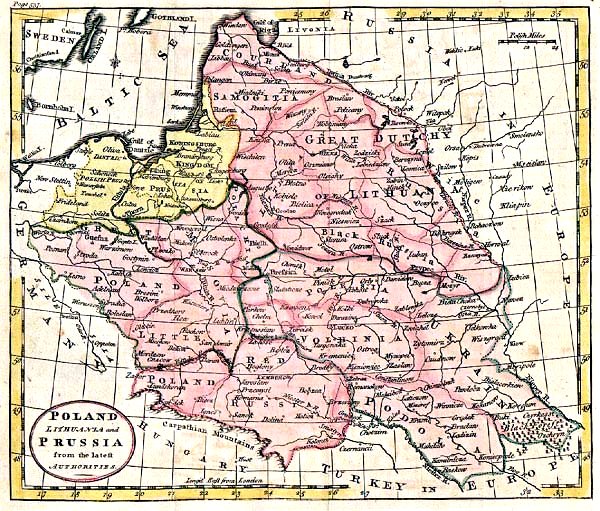
1787 Thomas Kitchin:
"POLAND, LITHUANIA
and PRUSSIA, from the
Latest AUTHORITIES,"
8.25 x 10.25 inches.
"POLAND, LITHUANIA
and PRUSSIA, from the
Latest AUTHORITIES,"
8.25 x 10.25 inches.


1787 Étienne André Philippe de Prétot (historian) - Maurille Antoine Moithey
(publisher): "CARTE NOUVELLE DE LA POLOGNE, Avant son demnmbrement," Paris,
14.5 x 10.5 inches, engraved by J.E.J. Vallet, from, his "Atlas universel pour l’étude
de la géographie et de l’histoire ancienne et moderne." In three versions, each
depicting the Commonwealth following the First, 1772, Partition. Farthest right from
www.raremaps.com

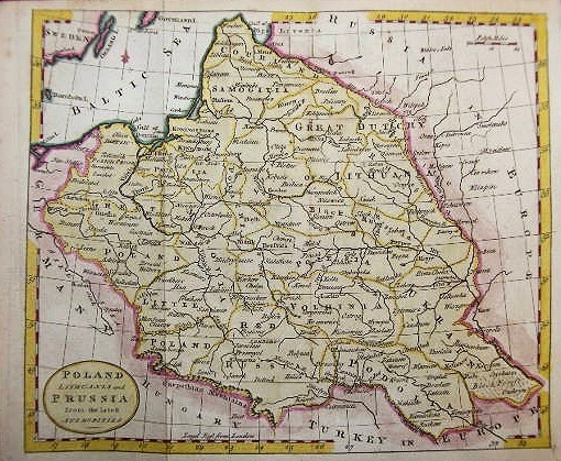
1787 Russell: "POLAND,
From the best
AUTHORITIES," 18.5 x
20.7 cm. From
www.mapmogul.com
From the best
AUTHORITIES," 18.5 x
20.7 cm. From
www.mapmogul.com
1788 F. A. Schraembl: "Generalkarte von
POLEN, LITAUEN...," Vienna. Four sheets
joined, 33.5 x 39 inches, from
"Allgemeiner Grosser Schrämblischer
Atlas." From www.swaen.com
POLEN, LITAUEN...," Vienna. Four sheets
joined, 33.5 x 39 inches, from
"Allgemeiner Grosser Schrämblischer
Atlas." From www.swaen.com

1789 Claude Buffier - J.P.
Gibrat: "LA POLOGNE."
5.5 x 7 inches.
Gibrat: "LA POLOGNE."
5.5 x 7 inches.

1790 Johann Christoph
Weigel: "...Samogitien
Lithauen..." Nuremburg,
11.5 x 14 inches / 29.5 x
35.5 cm, from "Atlas
Cosmographie Portatilis."
From www.mapsandmaps.com
Weigel: "...Samogitien
Lithauen..." Nuremburg,
11.5 x 14 inches / 29.5 x
35.5 cm, from "Atlas
Cosmographie Portatilis."
From www.mapsandmaps.com

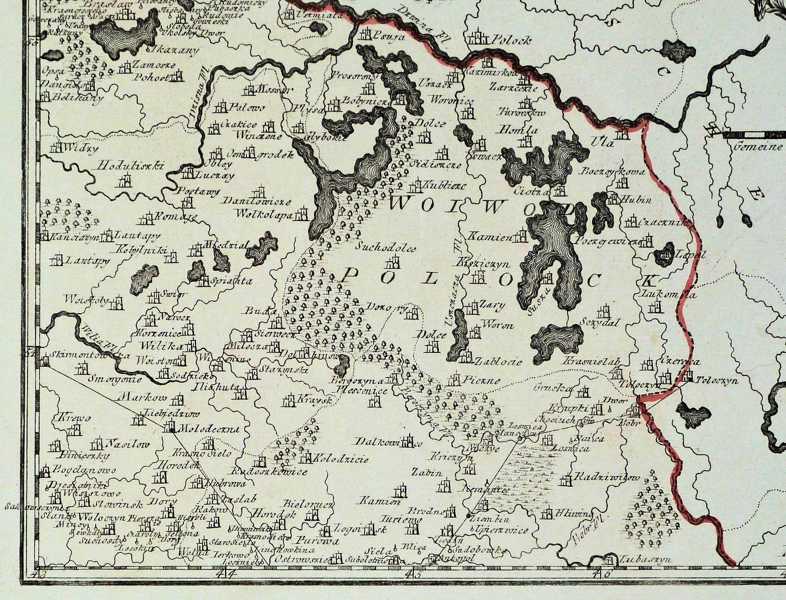
1791 Samuel John Neele (engraver) - H. John Trusler (priest/publisher): "A
Map of POLAND, with its Dismembered Provinces," 7 x 6.75 inches, in a
colored and uncolored version with a DETAIL image, from Trusler's "Portable
World Atlas." Uncolored version from cesgia on eBay
Map of POLAND, with its Dismembered Provinces," 7 x 6.75 inches, in a
colored and uncolored version with a DETAIL image, from Trusler's "Portable
World Atlas." Uncolored version from cesgia on eBay
1791 Franz Johann Joseph von Reilly: "Des
Grossherzogtums LITAUEN nord westlicher
Theil, Nro. 49," 9 x 11.5 inches. Also two
DETAIL images. One of a set of four Austrian
maps: NW, SW, NE, SE Lithuania. From Old
Leaf on eBay
Grossherzogtums LITAUEN nord westlicher
Theil, Nro. 49," 9 x 11.5 inches. Also two
DETAIL images. One of a set of four Austrian
maps: NW, SW, NE, SE Lithuania. From Old
Leaf on eBay
1792 Jan Barend Elwe: (publisher) - R. et J. Ottens (publishers): "LA POLOGNE. DIVISEE
EN ROYAUME DE POLOGNE ET LES ETATS Y PARTENANS LA POLOGNE, PRUSSIENNE,
AUTRICHIENNE & RUSSIENNE," Amsterdam, 24 x 17.5 inches, in two versions of the rare
sixth state of the map, first issued by Alexis Hubert Jaillot in 1694. First map AK-30, originally
fromwww.raremaps.com; second map from the New York Public Library's digital collection:
http://digitalcollections.nypl.org/items/2f4c3550-0195-0133-2cdc-58d385a7bbd0


1793 Jean-Baptiste- Louis
Clouet: "Pologne," Paris,
from a French school atlas.
Also two DETAIL images.
Clouet: "Pologne," Paris,
from a French school atlas.
Also two DETAIL images.

1793 Tobias Conrad Lotter: "MAPPA GEOGRAPHICA, ex novifsimis obfervationibus
repraesentans REGNUM POLONIAE ET MAGNUM DUCATUM LITHUANIAE." Augsburg,
19.125 x 22.875 inches. Originally created to reflect the results of the First, 1772, Partition,
the plate was altered to reflect the Second, 1793, Partition, and colored accordingly. First map
from www.alexandremaps.com; second from LIETUVOS DAILĖS FONDAS www.ldfondas.lt/en/collection

1793 Samuel John
Neele (engraver) - G.G.&
J. Robinson (publisher):
"POLAND and PRUSSIA,"
London, 7.5 x 8 inches /
19 x 20 cm. From eBay
Neele (engraver) - G.G.&
J. Robinson (publisher):
"POLAND and PRUSSIA,"
London, 7.5 x 8 inches /
19 x 20 cm. From eBay

1793 Johann Walch:
"CHARTE des Konigreiche
POLEN," Augsburg,
engraved by F.X. Hutter.
(See the 1773 version,
too.) From a 2003
Loeb-Larocque online auction
"CHARTE des Konigreiche
POLEN," Augsburg,
engraved by F.X. Hutter.
(See the 1773 version,
too.) From a 2003
Loeb-Larocque online auction

1794 Laurie & Whittle (Publisher): "A NEW
MAP OF THE KINGDOM OF POLAND, WITH
ITS DISMEMBERED PROVINCES, AND THE
KINGDM. OF PRUSSIA." London, 19.5 x 26
inches. Drawn by Thomas Kitchin based on
an earlier map of the region by D'Anville.
This important 1794 map depicts the
Kingdom of Poland during the brief
transitional period between the second
(1772) and third (1793) partitions. From
www.geographicus.com
1794 Robert Wilkinson: "POLAND, with its DISMEMBERED PROVINCES
Drawn from the Best Authorities," London, 10.5 x 13.5 inches / 27 x 34
cm., in two versions from Wilkinson's "General Atlas of the World." Shows
lands lost in the First and Second Partitions. First map from "Bookable" on eBay;
second from lylliegoods on eBay
Drawn from the Best Authorities," London, 10.5 x 13.5 inches / 27 x 34
cm., in two versions from Wilkinson's "General Atlas of the World." Shows
lands lost in the First and Second Partitions. First map from "Bookable" on eBay;
second from lylliegoods on eBay

1790 Alexander Kincaid:
"POLAND, LITHUANIA
and PRUSSIA From the
latest AUTHORITIES," 8.5
x 7 inches, from "A new
Geographical, Commercial
and Historic Grammer,"
Edinburgh. Beach Antique
Maps & Prints.
"POLAND, LITHUANIA
and PRUSSIA From the
latest AUTHORITIES," 8.5
x 7 inches, from "A new
Geographical, Commercial
and Historic Grammer,"
Edinburgh. Beach Antique
Maps & Prints.

1790 Claude Buffier:
"LA POLONIA," Venice,
16 x 20.5 cm, from the
Italian edition of his
"Geographie
Universelle." From
www.putmap.com
"LA POLONIA," Venice,
16 x 20.5 cm, from the
Italian edition of his
"Geographie
Universelle." From
www.putmap.com


1790 Anonymous:
"POLAND, LITHUANIA
and PRUSSIA" From
www.albion-prints.uk
"POLAND, LITHUANIA
and PRUSSIA" From
www.albion-prints.uk

1791 Franz Johann Joseph von Reilly: "GEN-
ERAL KARTE von der Koniglichen Republik
POLEN mit den verwandten Landernund
dem Konigreiche PREUSSEN, Nro. 34" Also
three DETAIL images. From Old Times Antique
Prints and Books on eBay
ERAL KARTE von der Koniglichen Republik
POLEN mit den verwandten Landernund
dem Konigreiche PREUSSEN, Nro. 34" Also
three DETAIL images. From Old Times Antique
Prints and Books on eBay


1791 Giovanni Antonio Rizzi-Zannoni
(Cartographer) - Antonio Zatta (Publisher):
"LI PALATINATI di WILNA, TROKI,
INFLANT..." Venice. 12.3 x 16 inches, in
two versions from "Atlante Polacco" (Atlas
of Poland). Second map from The Wroblewski
Library of the Lithuanian Academy of Sciences:
elibrary.mab.lt/
(Cartographer) - Antonio Zatta (Publisher):
"LI PALATINATI di WILNA, TROKI,
INFLANT..." Venice. 12.3 x 16 inches, in
two versions from "Atlante Polacco" (Atlas
of Poland). Second map from The Wroblewski
Library of the Lithuanian Academy of Sciences:
elibrary.mab.lt/

1787 Jean Lattre: "CARTE
GENERALE DE LA
POLOGNE.," 51 x 37 cm,
based on Rizzi-Zannoni,
from "Atlas Moderne."
GENERALE DE LA
POLOGNE.," 51 x 37 cm,
based on Rizzi-Zannoni,
from "Atlas Moderne."

1788 William Guthrie (geographer) -
Dilly & Robinson (publishers):
"POLAND, LITHUANIA and PRUSSIA
from the lateft Authorities," 22 x 18.5
cm. Also a DETAIL image. Compare
with the uncolored 1792 version
below. From antiqua.rare.books, Germany
Dilly & Robinson (publishers):
"POLAND, LITHUANIA and PRUSSIA
from the lateft Authorities," 22 x 18.5
cm. Also a DETAIL image. Compare
with the uncolored 1792 version
below. From antiqua.rare.books, Germany

1786-88 J. Keizer - Jan de
Lat of Deventer:
"t'KONINKRYK POLEN,"
Amsterdam, for Garvius'
"Nieuwe Zak en Reis-Atlas"
Lat of Deventer:
"t'KONINKRYK POLEN,"
Amsterdam, for Garvius'
"Nieuwe Zak en Reis-Atlas"


1791 Franz Johann Joseph von Reilly: "Des
Grossherzogtums LITAUEN nordöstlicher
Theil, Nro. 49," 9 x 11.5 inches. Also two
DETAIL images. One of a set of four Austrian
maps: NW, SW, NE, SE Lithuania. From
www.oldtimesrarebooks.com
Grossherzogtums LITAUEN nordöstlicher
Theil, Nro. 49," 9 x 11.5 inches. Also two
DETAIL images. One of a set of four Austrian
maps: NW, SW, NE, SE Lithuania. From
www.oldtimesrarebooks.com

1791 Franz Johann Joseph von Reilly: "Des
Grossherzogtums LITAUEN westsüdlicher
Theil, Nro. 50," 9 x 11.5 inches. Also two
DETAIL images. One of a set of four Austrian
maps: NW, SW, NE, SE Lithuania. From
www.oldtimesrarebooks.com
Grossherzogtums LITAUEN westsüdlicher
Theil, Nro. 50," 9 x 11.5 inches. Also two
DETAIL images. One of a set of four Austrian
maps: NW, SW, NE, SE Lithuania. From
www.oldtimesrarebooks.com


1791 Franz Johann von Reilly: "Die
Königliche REPUBLIK POLEN MIT
DEM Grossherzogthum LITHAUEN,
Nr. 38," Austria. From gkrgrec on eBay
Königliche REPUBLIK POLEN MIT
DEM Grossherzogthum LITHAUEN,
Nr. 38," Austria. From gkrgrec on eBay

1792 Alexandr Mihaili-
wich Wilbrecht (geo-
grapher of Empress of
Russia Catherine II):
"КАРТА РИЖСАГО" (Map
of the area around Riga),
St. Petersburg, 490 x 610
mm / 19.3 x 24 inches,
from "Atlas of Russia."
From the National Library of
Latvia via http://www.
theeuropeanlibrary.org/
wich Wilbrecht (geo-
grapher of Empress of
Russia Catherine II):
"КАРТА РИЖСАГО" (Map
of the area around Riga),
St. Petersburg, 490 x 610
mm / 19.3 x 24 inches,
from "Atlas of Russia."
From the National Library of
Latvia via http://www.
theeuropeanlibrary.org/


1787 Jean-Baptiste Louis Clouet: "DU ROYE.
DE PRUSSE. DUCHE DE LITHUANIE," Paris,
31 x 56 cm, from a French school atlas:
"Geographie moderne avec une
introduction." Compare with the 1791
version. From www.davidrumsey.com
DE PRUSSE. DUCHE DE LITHUANIE," Paris,
31 x 56 cm, from a French school atlas:
"Geographie moderne avec une
introduction." Compare with the 1791
version. From www.davidrumsey.com

1787 Robert Sayer (publisher): "A NEW MAP Of THE
KINGDOM Of POLAND with ITS DISMEMBERED
PROVINCES," London, 18½ x 25½ inches, in two
versions. The map also appeared in "Kitchin's General
atlas describing the whole universe." First map from
www.ritzlin.com; second from The Beinecke Rare Book &
Manuscript Library at Yale Univ.
KINGDOM Of POLAND with ITS DISMEMBERED
PROVINCES," London, 18½ x 25½ inches, in two
versions. The map also appeared in "Kitchin's General
atlas describing the whole universe." First map from
www.ritzlin.com; second from The Beinecke Rare Book &
Manuscript Library at Yale Univ.

1788 Maurille-Antoine
Moithey - Jean-Baptiste
Crepy: "CARTE NOU-
VELLE. Dressee pour
'intelligence de la guerre
...les roy. de Pologne...,"
from Moithey's "L'Europe
Divisee en tous ses Roy-
aumes." From Bibliotheque
nationale de France:
www.gallica.bnf.fr
Moithey - Jean-Baptiste
Crepy: "CARTE NOU-
VELLE. Dressee pour
'intelligence de la guerre
...les roy. de Pologne...,"
from Moithey's "L'Europe
Divisee en tous ses Roy-
aumes." From Bibliotheque
nationale de France:
www.gallica.bnf.fr

| 1787 John Cary (engraver) - John Seally (publisher): "POLAND shewing the Claims of AUSTRIA, RUSSIA & PRUSSIA," London, 6 x 7.7 inches, Originally published by John Fielding, this map is from "A Complete Geo- graphical Dictionary" by John Seally. The text underneath: "Published Aug.t 3 1782 by J.Fielding No 23 Pater-noster Row." has been erased. See the 1782 Fielding map. From www.swaen.com |


1787 Thomas Kitchin -
Robert Sayer (publisher):
"A new map of the King-
dom of Poland with its
dismembered provinces,"
London, 48 x 66 cm, at
1:2 450 000. From
www.davidrumsey.com
Robert Sayer (publisher):
"A new map of the King-
dom of Poland with its
dismembered provinces,"
London, 48 x 66 cm, at
1:2 450 000. From
www.davidrumsey.com


1788 J.E. Lange: "Neue Karte von den
gegen- wärtigen Kriegs-Schau- platze
zwischen den Russisch- Kayserl" (Map
of the war between Russia / the Kaiser
and the Otto- mans), Leipzig, From
www.swaen.com
gegen- wärtigen Kriegs-Schau- platze
zwischen den Russisch- Kayserl" (Map
of the war between Russia / the Kaiser
and the Otto- mans), Leipzig, From
www.swaen.com
1790 (Anon.) "POLAND,
LITHUANIA and PRUSSIA
From the latest AUTHOR-
ITIES," 8.6 x 7.25 inches.
Looks like the Kincaid
engraving to the left. From
www.murrayhudson.com
LITHUANIA and PRUSSIA
From the latest AUTHOR-
ITIES," 8.6 x 7.25 inches.
Looks like the Kincaid
engraving to the left. From
www.murrayhudson.com


1791 Franz Johann Joseph
von Reilly: "Des Grossherzog-
tums LITAUEN ostsüdlicher
Theil, Nro. 17," Austria, 18 x
12 inches, depicting Brest and
Navahradak in today's
Belarus. One of a set of four
maps: NW, SW, NE, SE
Lithuania From old-leaf on eBay
von Reilly: "Des Grossherzog-
tums LITAUEN ostsüdlicher
Theil, Nro. 17," Austria, 18 x
12 inches, depicting Brest and
Navahradak in today's
Belarus. One of a set of four
maps: NW, SW, NE, SE
Lithuania From old-leaf on eBay

1790 A.N Hackman:
"ПРУССIЯ, ПОЛЪША..."
St. Petersburg, from
"Atlas for Public Schools
of the Russian Empire."
From the National Library of
Russia: www.NLR.ru
"ПРУССIЯ, ПОЛЪША..."
St. Petersburg, from
"Atlas for Public Schools
of the Russian Empire."
From the National Library of
Russia: www.NLR.ru


1790 Louis Brion de la Tour - Louis Charles
Desnos: "Etats de Pologne et de Lithuanie
Divises par Palatinats et Provinces Eccles-
iastiques Avec le Roiaume de Prusse et le
Duche de Curlande," 16 x 21.5 inches,
showing boundaries set following the First,
1772, partition of the Polish-Lithuanian
Commonwealth. Also a DETAIL image. From
Desnos' "Geographie Moderne, Historique et
Politique." From www.oldworldauctionscom

c1793 "КАРТА...отб ПОЛЬШИ РОССIЕЮ...
1793" (Map of recently-acquired Polish-
Russian areas), from the "Atlas of the
Russian Empire." From www.karty.by
1793" (Map of recently-acquired Polish-
Russian areas), from the "Atlas of the
Russian Empire." From www.karty.by


1786 Richard Turner:
"Poland and Prussia," Lon-
don, 4 x 3 inches, from his
"A New and Easy Intro-
duction to Universal Geo-
graphy." From bertius on eBay
"Poland and Prussia," Lon-
don, 4 x 3 inches, from his
"A New and Easy Intro-
duction to Universal Geo-
graphy." From bertius on eBay
1787 1787 1787 1788 1788


1792 "Mogilve Province,"
created after the First Par-
tiiton. From radzima.net
created after the First Par-
tiiton. From radzima.net


1794 Samuel Dunn: "A New Map of the
King- dom of Poland with all its Divisions and
The Dismember'd Provinces," London, 12 x
17.5 inches / 30.5 x 44.5 cm. Also a DETAIL
image of the cartouche and of areas lost in
the First Partition, which Dunn correctly
calls "The Russian Province, dismembered
from Lithuania." From jremington1 on eBay


c1790 Edme Mentelle: "N° 4 (bis)
Dantzig," Paris, 79.9 x 56.8 cm,
possibly from "Carte de l'ancien
royaume de Pologne," published with
P.G. Chanlaire. From Old Times Rare
Antiquarian Books: cesgia on eBay
Dantzig," Paris, 79.9 x 56.8 cm,
possibly from "Carte de l'ancien
royaume de Pologne," published with
P.G. Chanlaire. From Old Times Rare
Antiquarian Books: cesgia on eBay


c1794 (Anon.): "Poland as
Divided," (London?), 8.25
by 10.5 inches, showing
the results of the Second,
1793, Partition. From
greypilgrimbooksandmaps
Divided," (London?), 8.25
by 10.5 inches, showing
the results of the Second,
1793, Partition. From
greypilgrimbooksandmaps


1792 Tomás López: "REYNOS DE
POLONIA Y PRUSIA," Madrid, 25 x 18
cm, from "'Atlas Elemental Moderno ó
Colección de Mapas para Enseñar a los
Niños Geografía con una idea de la
Esfera." Also two DETAIL images. From
boughettiarte on eBay
POLONIA Y PRUSIA," Madrid, 25 x 18
cm, from "'Atlas Elemental Moderno ó
Colección de Mapas para Enseñar a los
Niños Geografía con una idea de la
Esfera." Also two DETAIL images. From
boughettiarte on eBay

1792 John Gibson -
Emanuel Bowen:
"POLAND," London,
miniature, published by
L. Piguemi, that is
almost, but not exactly, a
duplicate of the 1774
version -- see if you can
find the differences. See
also the first, 1758,
version From cesgia on eBay
Emanuel Bowen:
"POLAND," London,
miniature, published by
L. Piguemi, that is
almost, but not exactly, a
duplicate of the 1774
version -- see if you can
find the differences. See
also the first, 1758,
version From cesgia on eBay

1789 Franz Johann
Joseph von Reilly: "GEN-
ERAL KARTE von der
Koniglichen Republik
POLEN mit den ver-
wandten Landernund
dem Konigreiche
PREUSSEN, Nro. 34,
Compare with the 1791
version. From
antiquariat-paulisch.de
Joseph von Reilly: "GEN-
ERAL KARTE von der
Koniglichen Republik
POLEN mit den ver-
wandten Landernund
dem Konigreiche
PREUSSEN, Nro. 34,
Compare with the 1791
version. From
antiquariat-paulisch.de
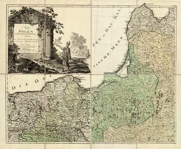


1793 Carl Christian Glassbach, August F. Schmidt, Daniel Friedrich Sotzmann, "Karte von Polen und den angränzenden Provinzen," Berlin, 97 x 118 cm, at 1:1
200 000. Published immediately after the Second Pasrtition of 1793, showing pre-Partition and First, 1772, Partition boundaries. From the Polish National Library via
www.polona.pl
200 000. Published immediately after the Second Pasrtition of 1793, showing pre-Partition and First, 1772, Partition boundaries. From the Polish National Library via
www.polona.pl


1786 Louis Brion de la Tour: "Etats De Pologne Et
Lituanie..." Paris, in two versions. First map from
www.raremaps.com; second from The Wroblewski Library of the
Lithuanian Academy of Sciences: elibrary.mab.lt/
Lituanie..." Paris, in two versions. First map from
www.raremaps.com; second from The Wroblewski Library of the
Lithuanian Academy of Sciences: elibrary.mab.lt/
1786 Louis Brion de la
Tour: "La Russie
Europeenne," Paris. From
www.raremaps.com
Tour: "La Russie
Europeenne," Paris. From
www.raremaps.com

1787 Franz Anton
Schrambl: "Ost Preussen,"
Vienna, depicting the
Memelland from his
"Algemeiner Grosser
Atlas," begun in 1786,
completed in 1800. From
senizemelepiai.lt
Schrambl: "Ost Preussen,"
Vienna, depicting the
Memelland from his
"Algemeiner Grosser
Atlas," begun in 1786,
completed in 1800. From
senizemelepiai.lt


1793 William Perks: "Poland and Prussia," London,
from "The Youth's General Introduction to Geography
....comprising a Complete Pocket Atlas: ...', published
by G.G. and J. Robinson. From angelikamapwoman on eBay
from "The Youth's General Introduction to Geography
....comprising a Complete Pocket Atlas: ...', published
by G.G. and J. Robinson. From angelikamapwoman on eBay

1793 William Faden: "A Map of the King-
dom of Poland and the Grand Dutchy of
Lithuania, with their Dismembered
Provinces," dated 1792, but colored to
show the results of the 1793 Partition.
From Biblioteca Virtual del Patrimonio Bibliográfico
http://bvpb.mcu.es/
dom of Poland and the Grand Dutchy of
Lithuania, with their Dismembered
Provinces," dated 1792, but colored to
show the results of the 1793 Partition.
From Biblioteca Virtual del Patrimonio Bibliográfico
http://bvpb.mcu.es/

1793 Homann Heirs - Tobias Mayer:
"Mappa Geographica Regni Poloniae ex
novissimis... Stereographicae projectionis
revocata a Tob. Mayero...MDCCLXXIII,"
dated 1773, but updated on the plate and
by the colorist to reflect the Second, 1793,
Partition. From www.raremaps.com
"Mappa Geographica Regni Poloniae ex
novissimis... Stereographicae projectionis
revocata a Tob. Mayero...MDCCLXXIII,"
dated 1773, but updated on the plate and
by the colorist to reflect the Second, 1793,
Partition. From www.raremaps.com


1791 Jean-Baptiste Louis
Clouet: "DUCHE DE LITH-
UANIE," as a full page
in a French school atlas.
Compare with the 1787 version. From the
National Library of Latvia:http://
data.lnb.lv/nba05/kartes/frame_anglu.htm
Clouet: "DUCHE DE LITH-
UANIE," as a full page
in a French school atlas.
Compare with the 1787 version. From the
National Library of Latvia:http://
data.lnb.lv/nba05/kartes/frame_anglu.htm

1790 Louis Brion de la
Tour: "Etats de Pologne et
de Lithuanie Divises par
Palatinats e Provinces
Ecclesiastiques," Paris,
11.5 x 12.5 inches. From
www.raremaps.com
Tour: "Etats de Pologne et
de Lithuanie Divises par
Palatinats e Provinces
Ecclesiastiques," Paris,
11.5 x 12.5 inches. From
www.raremaps.com

1793 Antonio Zatta: "Carta Del Regno di
Polonia che cintostra il partaggio fatto
Dalle Potenze Europee nell' anno 1773 e.
nel corrente 1793..." Venice, 26 x 20
inches, showing effects of the First
Partition. From www.raremaps.com
Polonia che cintostra il partaggio fatto
Dalle Potenze Europee nell' anno 1773 e.
nel corrente 1793..." Venice, 26 x 20
inches, showing effects of the First
Partition. From www.raremaps.com


1789 Bartolomeo Borghi
(engraver/cartographer): '
Il Granducato dI Lituania
Diviso ne Suoi Palatinati,"
Sienna, from his "Atlante
Geografico," published
1788-1800. From
LIETUVOS DAILĖS FONDAS
ldfondas.lt/
en/collection
(engraver/cartographer): '
Il Granducato dI Lituania
Diviso ne Suoi Palatinati,"
Sienna, from his "Atlante
Geografico," published
1788-1800. From
LIETUVOS DAILĖS FONDAS
ldfondas.lt/
en/collection
1789 Bartolomeo Borghi
(engraver/cartographer):
"Ciò che fu e ciò che è al
presente la Polonia,"
Sienna, from his "Atlante
Geografico," published
1788-1800. From
LIETUVOS
DAILĖS FONDAS ldfondas.lt/
en/collection
(engraver/cartographer):
"Ciò che fu e ciò che è al
presente la Polonia,"
Sienna, from his "Atlante
Geografico," published
1788-1800. From
LIETUVOS
DAILĖS FONDAS ldfondas.lt/
en/collection

1789 Samuel Dunn (map-
maker) - Robert Sayer
(publisher): "A new map of
the Kingdom of Poland
with all its divisions and
the dismember'd
provinces," London, from
"A New Atlas..." From the
New York Public Library:
http://digitalcollections.nypl.org
maker) - Robert Sayer
(publisher): "A new map of
the Kingdom of Poland
with all its divisions and
the dismember'd
provinces," London, from
"A New Atlas..." From the
New York Public Library:
http://digitalcollections.nypl.org
