Maps: 1770 - 1775

1770 Gilles Robert de Vaugondy: "POLOGNE," Paris, 16
x 15 cm, from "Methode Abregee et Facile Pour
Apprendre La Geographie," published by A Paris Chez
les Libraires in two versions. Left: www.miklianmaps.com;
right: http://www.ebay.com/sch/bertius/m.html
x 15 cm, from "Methode Abregee et Facile Pour
Apprendre La Geographie," published by A Paris Chez
les Libraires in two versions. Left: www.miklianmaps.com;
right: http://www.ebay.com/sch/bertius/m.html

1770 Thomas Kitchin:
"POLAND, LITHUANIA
and PRUSSIA."
"POLAND, LITHUANIA
and PRUSSIA."

1771 Anton Freiderich
Busching: "REGNI
POLONIAE," Nuremburg.
From www.alexandremaps.com
Busching: "REGNI
POLONIAE," Nuremburg.
From www.alexandremaps.com

1771, 1772 (x2), 1771 Thomas Jeffreys: "POLAND, LITHUANIA and PRUSSIA," 7 x 8 inches / 240 x 190 mm, in three
differently-colored iterations, from atlases published by Thomas Salmon titled "A New Geographical and Historical
Grammar." Second from left map from www.pastpages.co.uk; third from left map from Bartick Antique Prints; farthest right map from Beach
Antique Maps and Prints, Canada
differently-colored iterations, from atlases published by Thomas Salmon titled "A New Geographical and Historical
Grammar." Second from left map from www.pastpages.co.uk; third from left map from Bartick Antique Prints; farthest right map from Beach
Antique Maps and Prints, Canada


1771 Theodor Phillip.von Pfau: "Tabula POLONIAE et LITUANIAE. Geographica
minor," 46.5 x 51.5 cm. The upper left corner map of a 25-sheet map called
"Regni Poloniae, Magni Ducatus Lituaniae..." engraved by Christian Benjamin
Glassbach. Also two DETAIL images. From andrzey.florczyk@t-online.de
minor," 46.5 x 51.5 cm. The upper left corner map of a 25-sheet map called
"Regni Poloniae, Magni Ducatus Lituaniae..." engraved by Christian Benjamin
Glassbach. Also two DETAIL images. From andrzey.florczyk@t-online.de
| 1771 Giovanni Antonio Rizzi- Zannoni: "CARTE GENERALE DE LA POLOGNE," 12 x 17.75 inches / 30.5 x 45.1 cm. Also plate No. 10 in Jean Lattre's 1775 "Atlas Moderne ou Collection de Cartes sur Toutes les Parties du Globe Terrestre." From www.geographicus.com |

1772 Bell: "A MAP of POLAND, with the APPENDAGES
shewing," from Scots Magazine on the left, and from
Gentlemens Magazine on the right, with one word
changed and colored.
shewing," from Scots Magazine on the left, and from
Gentlemens Magazine on the right, with one word
changed and colored.


| 1772 Matthaus Lotter - Matthaus Seutter: "POLONIAE REGNUM ut et MAGNI DUCAT LITHUANIAE." 27.5 x 22 cm. Also two DETAIL images. From andrzey.florczyk@t-online.de |


1773 Tobias Mayer- Homann Heirs: "Mappa Geographica REGNI POLONIAE,"
Nuremberg, 18.9 x 20.9 inches, in three versions. First map from:
http://gauss.suub.uni-bremen.de; second: www.alexandremaps.com; third from orso47 on eBay, which
is also www.storchiantiques.com
Nuremberg, 18.9 x 20.9 inches, in three versions. First map from:
http://gauss.suub.uni-bremen.de; second: www.alexandremaps.com; third from orso47 on eBay, which
is also www.storchiantiques.com
| 1773 Tobias Mayer - Homan Heirs: "Mappa Geographica REGNI POLONIAE," 17.63 x 20.63 inches, Nuremberg, from “Atlas Geographicus,” first published in 1759, reissued to c1784. AK- 09. Note the ornate engraving on the bottom left, compared with the same area in the ones to the left. |


1773 Emanuel Bowen: "POLAND, LITHUANIA and
PRUSSIA." Also a DETAIL image.
PRUSSIA." Also a DETAIL image.

1773 Johann Walch:
"CHARTE des Konigreichs
POLEN." (See the 1793
version, too.)
"CHARTE des Konigreichs
POLEN." (See the 1793
version, too.)

1773 Antonio Zatta:
"CARTE DEL REGNI DI
POLONIA," Venice.
"CARTE DEL REGNI DI
POLONIA," Venice.
| 1775 Jean Lattre - Giovanni Antonio Rizzi-Zannoni: "CARTE GENERALE DE LA POLOGNE," Paris, 38 x 55 cm, from Herrisot's "Atlas Moderne."Compare with the 1771 version. From www.mapmogul.com |


1773-80 Guillaume de L'Isle - Philippe Buache: "LA
POLOGNE Dressee sur ce qu'en ot donne Starovolsk,
Beauplan, Hartnoch...," published 1773-80, Paris,
18.8 x 24.3 inches / 47.9 x 61.8 cm. The cartouche
gives credit for the map to Guillaume Beauplan de le
Vasseur, Hartnoch and others. The copper plate
shows many erasures. Also a DETAIL image. From
Paulus Swaen: www.swaen.com.

1774 Jean Janvier - Jean Lattre: "LES
ROYAUMES DE POLOGNE ET DE
PRUSSE, AVEC LE DUCHE DE
CURLANDE..." Paris, 25.5 x 18.5
inches. First issued 1760, updated
through 1780 (on the next page). From
www.raremaps.com
ROYAUMES DE POLOGNE ET DE
PRUSSE, AVEC LE DUCHE DE
CURLANDE..." Paris, 25.5 x 18.5
inches. First issued 1760, updated
through 1780 (on the next page). From
www.raremaps.com


1773 Michael Groell (printer/publisher
/book-seller) - Bartolomeo Folino
(engraver): "CARTE Generale &
Itineraire de POLOGNE," Warsaw. From
www.ornatowski.com/maps
/book-seller) - Bartolomeo Folino
(engraver): "CARTE Generale &
Itineraire de POLOGNE," Warsaw. From
www.ornatowski.com/maps


c1771 "Tabula Poloniae
et Lituaniae"
et Lituaniae"


| 1773 Thomas Kitchin: "POLAND, LITHUANIA and PRUSSIA. Drawn from the latest Authorities," and two DETAIL images. Compare with the 1785 version. |

| 1772 W. Barker: "POLAND, Shewing the Claims of Russia, Prussia and Austria, until the late DEPRADATIONS ..," engraved for Carey's American edition of "Guthrie's Geography improved." From www.karty.by |


1770 Jacob Friedrich Schmidt: ("Revelskaya Guberniya...")Provincia
Revaliensis sive Estlandia quatuor Dioecesibus contenta com Finitimis
Insulis Dago..." Map prepared in Latin as well as in Russian Cyrillic.
From http://dspace.utlib.ee/dspace/handle/10062/8557
Revaliensis sive Estlandia quatuor Dioecesibus contenta com Finitimis
Insulis Dago..." Map prepared in Latin as well as in Russian Cyrillic.
From http://dspace.utlib.ee/dspace/handle/10062/8557

1772 J. H. Schneider:
"POLAND and LITHU-
ANIA," Amsterdam, 3.75 x
4.75 inches, after de l'Isle,
from "Atlas des Enfans."
From mappamundi-fr on eBay
"POLAND and LITHU-
ANIA," Amsterdam, 3.75 x
4.75 inches, after de l'Isle,
from "Atlas des Enfans."
From mappamundi-fr on eBay


| 1770 "DUCATUUM CUR- LANDIAE et SEMIGALL- IAE," with two DETAIL images, The National Library of Latvia: http://data.lnb.lv/ nba05/kartes/frame_anglu.htm |
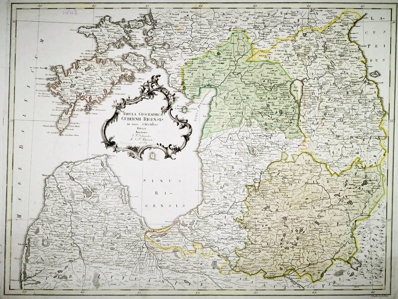
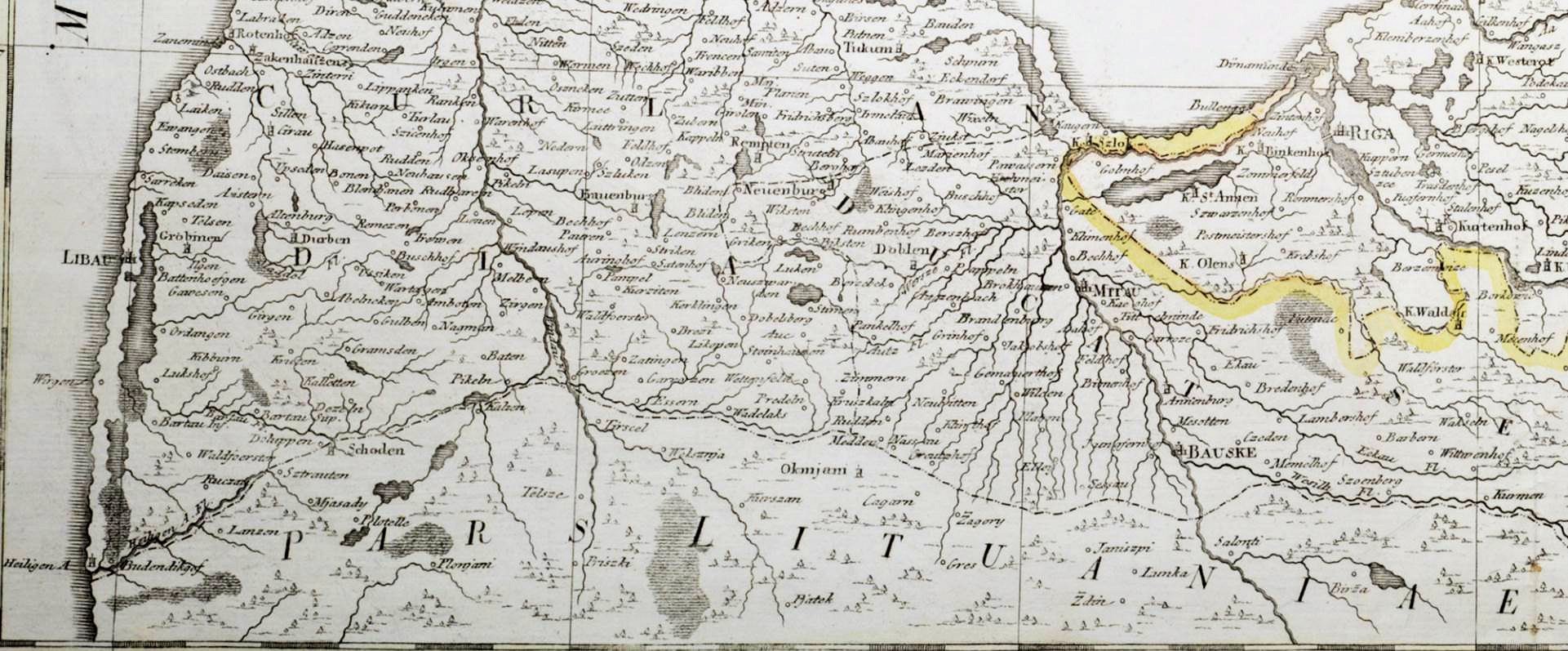
| 1772 Georg Friedrich Schmidt: "TABULA GEOGRAPHICA GUBERNII RIGENSIS in suos circulos Divisi," Denmark, image 18.8 x 23.4 inches. Also a DETAIL image. From the Naional Library of Latvia: http: //data.lnb. lv/nba05/karte s/frame_anglu. htm |


1773 Georges-Louis Le
Rouge: "Le Royaume de
Pologne, le Grand duche
Lithuanie, avec le
demembrement du traite
du 5 aout 1772," Paris.
From Bibliotheque nationale de
France: www.gallica.bnf.fr
Rouge: "Le Royaume de
Pologne, le Grand duche
Lithuanie, avec le
demembrement du traite
du 5 aout 1772," Paris.
From Bibliotheque nationale de
France: www.gallica.bnf.fr

1770 Jacque Nicolas
Bellin: "CARTE DU ROY-
AUME DE POLOGNE et
ses Frontieres," Paris,
45.5 x 51.5 cm. From
Bibliotheque nationale de
France: www.gallica.bnf.fr
Bellin: "CARTE DU ROY-
AUME DE POLOGNE et
ses Frontieres," Paris,
45.5 x 51.5 cm. From
Bibliotheque nationale de
France: www.gallica.bnf.fr


1770 Christian Benjamin
Glassbach (engraver):
"TABULA POLONIAE et
LITUANIAE, " 47 x 52
cm, the opening map for
Glassbach (engraver):
"TABULA POLONIAE et
LITUANIAE, " 47 x 52
cm, the opening map for
a suite of maps published as "Regni Poloniae, magni ducatus
Lituaniae nova mappa geographica." The four smaller thumbnails
are placeholders until I can get better images than the Biblio-
theque nationale de France (www.gallica.bnf.fr) currently offers.
Lituaniae nova mappa geographica." The four smaller thumbnails
are placeholders until I can get better images than the Biblio-
theque nationale de France (www.gallica.bnf.fr) currently offers.
# 2 # 3
# 7 # 8

| 1772 Giovanni Antonio Rizzi-Zannoni: "WIZER- UNEK POWSZECH- NY POLSKIY LITWY...," 34 x 53.5 cm. with chart of Polish and Lith- uanian "voivodes," or provincial governors From Bibliotheque nationale de France: www.gallica.bnf.fr |
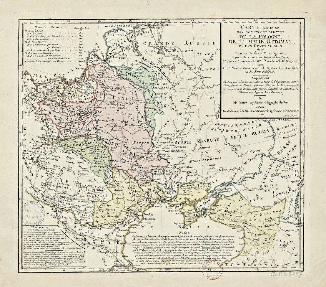
| 1775 Louis Brion de la Tour: "CARTE CURIEUSE DES NOUVELLES LIMITES DE LA POLOGNE, DE L'EMPIRE OTTOMAN ET DES ETATS VOISINS FIXEES; par les puissances copartageantes, par la paix entre les Russes et les Turcs..." ("MAP OF THE CURIOUS NEW LIMITS OF POLAND, THE OTTOMAN EMPIRE AND THE UNITED NEIGHBORS FIXED, by partitioning Powers, for peace between the Russians and Turks"), Paris, 41.5 x 49.5 cm. From Bibliotheque nationale de France: www.gallica.bnf.fr |


c1770 Rigobert Bonne:
"ROYAUME DE POLOGNE,"
Paris, 35 x 24 cm. From gkgrec on eBy
"ROYAUME DE POLOGNE,"
Paris, 35 x 24 cm. From gkgrec on eBy


1772 Robert Sayer
(publisher): "THE KING-
DOM OF POLAND and
GREAT DUTCHY OF
LITHUANIA," London,
18.7 x 25.4 inches. From
www.alexandremaps.com
(publisher): "THE KING-
DOM OF POLAND and
GREAT DUTCHY OF
LITHUANIA," London,
18.7 x 25.4 inches. From
www.alexandremaps.com

1775 Leonhard Euler:
"Tabula Geographica
REGNI POLONIAE,"
Germany, 13 x 15
inches. From
www.alexandremaps.com
"Tabula Geographica
REGNI POLONIAE,"
Germany, 13 x 15
inches. From
www.alexandremaps.com

1772 Rigobert Bonne:
"ROYAUME DE
POLOGNE ET DUCHE DE
LITHUANIE," Paris, 9.1 x
13.7 inches. From
www.alexandremaps.com
"ROYAUME DE
POLOGNE ET DUCHE DE
LITHUANIE," Paris, 9.1 x
13.7 inches. From
www.alexandremaps.com

1772 Matthaus Lotter:
"MAPPA GEOGRAPHICA
...REGNUM POLONIAE
ET MAGNUM DUCATUM
LITHUANIAE," Augsburg.
From the Lithuanian National
Museum: lnm.lt
"MAPPA GEOGRAPHICA
...REGNUM POLONIAE
ET MAGNUM DUCATUM
LITHUANIAE," Augsburg.
From the Lithuanian National
Museum: lnm.lt
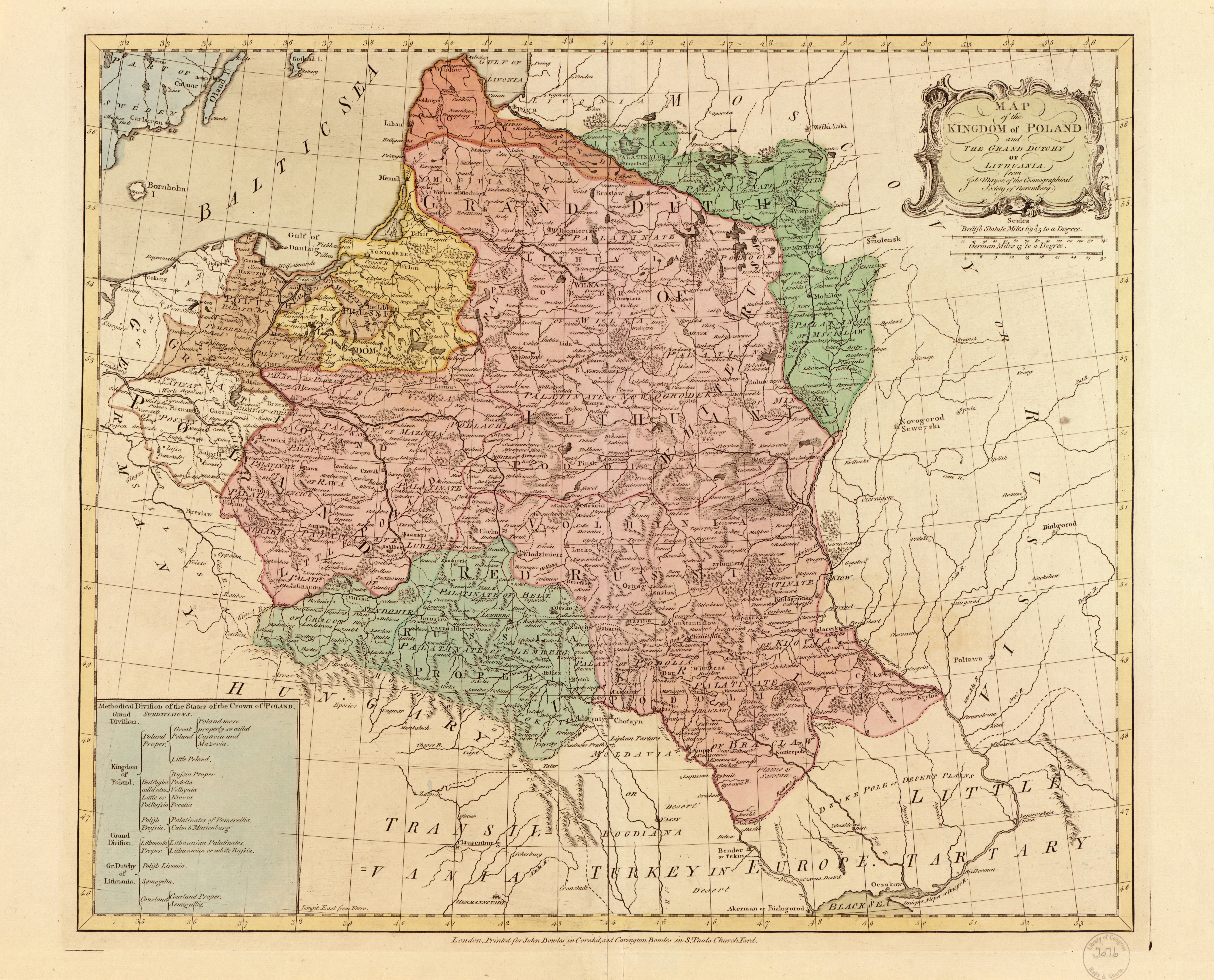
| c1772 Tobias Mayer: "Map of the Kingdom of Poland : and the Grand Dutchy of Lithuania / from Tob. Mayer of the Cosmographical Society of Nuremberg," London. From the Library of Congress, Geography and Map Division. http://memory.loc.gov/c gi-bin/query/D?gmd:6:./t emp/~ammem_ijqy |

| c1772 Tobias Mayer: "MAGN. DVCATVS LITVANIAE," published after the 1749 version printed on the map by Homann Heirs. From the Lithuanian national museum: lnm.lt |


1775 Homann Heirs: "CHARTE von RUSSISICH
LITAUEN, welche die von Polen an Russland
abgetretene Woiewodschaften, Liefland,
Witepsk, Msciflaw, und einen Theil der
Woiewodsdchaften Polock und Minsk enthalt,"
Nürnberg, 23 x 20 inches, showing the lands of
the Grand Duchy of Lithuania annexed to
Russian Empire after the first, 1772, partition
of the Polish-Lithuanian state. Also a DETAIL
image. From the Lithuanian national museum: lnm.lt