Maps: 1577 - 1593
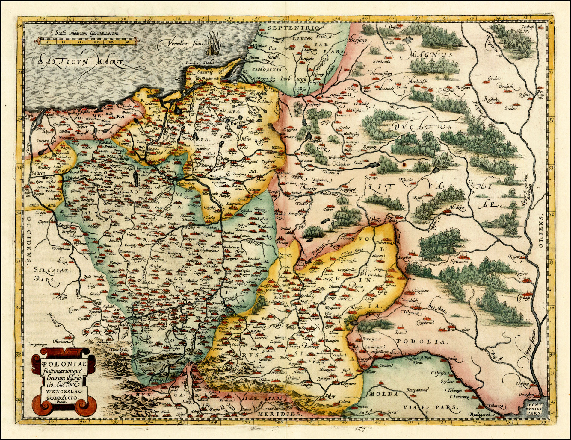
Vaclovas Grodeckis (original mapmaker, in 1558) - Abraham Ortelius: (geographer/publisher): "POLONIAE finitimarumque locorum descriptio, Auctore Wenceslao Godreccio, Polono,” from "Theatrum Orbis
Terrarum," initially published 1570 in Antwerp at 19.5 x 14.5 inches / 38 x 50.5 cm., but later published in many different sizes, and acknowledged as the first atlas.
Terrarum," initially published 1570 in Antwerp at 19.5 x 14.5 inches / 38 x 50.5 cm., but later published in many different sizes, and acknowledged as the first atlas.

1585 Abraham Ortelius -
Philippe Galle: "POLONIÆ
DESCRIPTIO," 7.5 x 10.3
cm, from Ortelius'-
Godreccio's "Il Theatro del
Mondo. From
www.mapmogul.com
Philippe Galle: "POLONIÆ
DESCRIPTIO," 7.5 x 10.3
cm, from Ortelius'-
Godreccio's "Il Theatro del
Mondo. From
www.mapmogul.com
Sebastian Munster: "Landtafel des Ungerlands / Polands / Reussen /Littaw / Walachen und Bulgaren," Basle, 14 x 10 inches, in versions redrawn
from the original plate from "Geographia Universalis." These maps are from "Cosmographia Universalis," published 1544 - 1628, and one of the
most influential works of the 16th Century.
from the original plate from "Geographia Universalis." These maps are from "Cosmographia Universalis," published 1544 - 1628, and one of the
most influential works of the 16th Century.
1588 Sebastian Munster:
"Prussen," 5.5 x 3.5
inches, from "Cosmo-
graphia." (See "Neman"/
Nemunas River up top,
along with Neringa and
Memel/Klaipeda area.)
From Beach Antique Maps &
Prints: cesgia on eBay
"Prussen," 5.5 x 3.5
inches, from "Cosmo-
graphia." (See "Neman"/
Nemunas River up top,
along with Neringa and
Memel/Klaipeda area.)
From Beach Antique Maps &
Prints: cesgia on eBay
1589 Maciej Strubicz (cartographer) -
Gerard Mercator (engraver) - Martin
Kromer (publisher): "Magni Dvcatvs
Lithvaniӕ Livoniӕ et Moscoviӕ
Descriptio," 39 x 32 cm. Strubicz's only
surviving map. From wikimedia
Gerard Mercator (engraver) - Martin
Kromer (publisher): "Magni Dvcatvs
Lithvaniӕ Livoniӕ et Moscoviӕ
Descriptio," 39 x 32 cm. Strubicz's only
surviving map. From wikimedia


1592 Abraham Ortelius:
"POLONIA." See the nearly
identical map in a 1598
French edition, published
by Philippe Galle.
"POLONIA." See the nearly
identical map in a 1598
French edition, published
by Philippe Galle.
1592 Johannes Busse-
macher: "Poloniae finiti-
marum que locurum
descripio auctore," 18.0 x
26.6 cm. Based on
Ortelius' version of
Grodeckis' map
(originally published by
Matthias Quad in
"Geograph- isch
Handtbuch"). From
www.mapmogul.com
macher: "Poloniae finiti-
marum que locurum
descripio auctore," 18.0 x
26.6 cm. Based on
Ortelius' version of
Grodeckis' map
(originally published by
Matthias Quad in
"Geograph- isch
Handtbuch"). From
www.mapmogul.com

1593 Matthias Quad: "Prussiæ Descriptio."
Published by Bussemacher, this 11.1 x
13.9 inch map appears to have been based
on the Munster map to the left, but has
more detail. This is a detail image, with
the complete map at the upper left. From
www.vintage-maps.com
Published by Bussemacher, this 11.1 x
13.9 inch map appears to have been based
on the Munster map to the left, but has
more detail. This is a detail image, with
the complete map at the upper left. From
www.vintage-maps.com


c. 1577-79 Jan Portant (original 1573 mapmaker) - Abraham Ortelius (re-engraver) - Philippe Galle (second re-engraver, reducing Ortelius'
plate/publisher) : "Livonia nuoa de scriptio Ioanne Portantio auctore," Antwerp, from the first French edition of "Le Miroir du Monde."
plate/publisher) : "Livonia nuoa de scriptio Ioanne Portantio auctore," Antwerp, from the first French edition of "Le Miroir du Monde."


1592 Matthias Quad (geographer/engraver/publisher): "Poloniæ finitimarumque locorum
descriptio Auctore Wenceslau Godretcio..," Cologne, 11.5 x 8.5 inches, based on Grodeckis'
map, first published in 1558.
descriptio Auctore Wenceslau Godretcio..," Cologne, 11.5 x 8.5 inches, based on Grodeckis'
map, first published in 1558.


| 1579 www.alexandremaps.com |
| 1587 World Digital Library: http://www.wdl.org |

| 1580 |
1590 Gerard Mercator:
"LIVONIA," image 36.7
x 47.5 cm, published in
France. From the National
Library of Latvia:
http://data.lnb.lv
"LIVONIA," image 36.7
x 47.5 cm, published in
France. From the National
Library of Latvia:
http://data.lnb.lv
1577-95 Abraham
Ortelius - Philip Galle:
"Poloniæ descriptio.,"
Antwerp, 15.1 x 17.3
inches, in two images,
from Ortelius' "Epitome
Theatri Ortelianai," as
engraved/ published by
Galle. From www.swaen.com
Ortelius - Philip Galle:
"Poloniæ descriptio.,"
Antwerp, 15.1 x 17.3
inches, in two images,
from Ortelius' "Epitome
Theatri Ortelianai," as
engraved/ published by
Galle. From www.swaen.com


Abraham Ortelius - Jan Portant (original mapmaker) - Christoffel Plantin (publisher): "LIVONIAE NOVA DESCRIPTIO." Antwerp, 21 x 23 cm. One of
three map images printed on one sheet from his "Theatrum Orbis Terrarum." The other two: "Pomeranianae, Wandalicae regionis typ.; Ducatus
Oswiczensis et Zatoriensis descriptio." Originally created by Portant in 1573.
three map images printed on one sheet from his "Theatrum Orbis Terrarum." The other two: "Pomeranianae, Wandalicae regionis typ.; Ducatus
Oswiczensis et Zatoriensis descriptio." Originally created by Portant in 1573.

| 1584 www.raremaps.com |


| 1580 |


1578 Gerard de Jode (engraver/cartographer) - Gerard
Smits (publisher): "Livoniæ provinciæ ac eius confinium
Verus et elegans typus Io Portantius cosmographus
delinea," Antwerp. Left half of a plate, measuring 325 x
505 mm / 12.75 by 20 inches, in "Speculum Orbis
Terrarum." The right half shows “Moscoviae..."
Smits (publisher): "Livoniæ provinciæ ac eius confinium
Verus et elegans typus Io Portantius cosmographus
delinea," Antwerp. Left half of a plate, measuring 325 x
505 mm / 12.75 by 20 inches, in "Speculum Orbis
Terrarum." The right half shows “Moscoviae..."

1587 Stanisław Sarnicki: [Untitled] from
Annales sive de originis et rebus gestis
Polonorvm et Litvanorvm" (Chronicle of
the origins and history of Poles and
Lithuanians), Cracow, as a manuscript
map. From Małopolska Biblioteka Cyfrowa, via
www.mapywig.org
Annales sive de originis et rebus gestis
Polonorvm et Litvanorvm" (Chronicle of
the origins and history of Poles and
Lithuanians), Cracow, as a manuscript
map. From Małopolska Biblioteka Cyfrowa, via
www.mapywig.org


1593 Jan Portant (mapmaker)
- Johann and Lucas Doetichum
(Deutium) (engravers) -
Cornelis de Jode (publisher):
"Livoniӕ Provinciӕ..., "
Antwerp, from Vol. 2 of
"Speculum Orbis Terrarum."
From the National Library of Finland:
http://www.doria.fi/
- Johann and Lucas Doetichum
(Deutium) (engravers) -
Cornelis de Jode (publisher):
"Livoniӕ Provinciӕ..., "
Antwerp, from Vol. 2 of
"Speculum Orbis Terrarum."
From the National Library of Finland:
http://www.doria.fi/
| 1579 www.alteagallery.com |
| 1579 www.sanderusmaps.com |
| 1581 www.raremaps.com |
| 1581 www.raremaps.com |
| 1584 www.swaen.com |
| 1584 www.raremaps.com |
| 1592 |
| 1592 www.themaphouse.com |
| c. 1578 www.raremaps.com |
| 1588 |
| 1588 twinghiwin on eBay |
| 1588 cesgia on eBay |

| 1587 www.raremaps.com |
| 1590 |
| 1590 oldleaf on eBay |

| 1584 www.raremaps.com |
| smardic on eBay |
| bertius on eBay |
| cesgia on eBay |
| www.oshermaps.org |

| 1584 Harvard Map Collection: http://vc.lib.harvard.edu |


| www.maratyanlan.com |
| Harvard Map Collection: http://vc.lib.harvard.edu |
| CARTOGRAPHIA RAPPERSVILIANA POLONORUM: http://mapy.muzeum-polskie.org/ |
1593 Cornelius de Jode (engraver/publisher): "Poloniӕ Amplissimi Regni [Most noble Kingdom) ..Typvs Geographicvs," Antwerp, 15 x 19¼
inches, in three versions from the second edition of two of the de Jode atlas. This was a new map, completely revising the map of Poland of
the 1578 edition. In addition to substantial cartographic changes, this edition added at lower left the portrait of King Sigismund the Third
(1566-1632), ruler of the Polish-Lithuanian Commonwealth from 1587 (noted on the map) to the year of his death. While highly regarded
by scholars today, De Jode's atlas in which this map appeared was, commercially, no match for Ortelius's.

| 1589 www.browncollection.com |

| 1579 Wroblewski Library of the Lithuanian Academy of Sciences: elibrary.mab.lt/ |

1579 Abraham Ortelius (mapmaker) -
Philippe Galle (publisher): "Poloniae
Descrip.," Antwerp, 4 x 3 inches, from
the first French edition of "Le Miroir du
Monde." See the 1600 version. From Beach
Antique Maps & Prints: bertius on eBay
Philippe Galle (publisher): "Poloniae
Descrip.," Antwerp, 4 x 3 inches, from
the first French edition of "Le Miroir du
Monde." See the 1600 version. From Beach
Antique Maps & Prints: bertius on eBay

| www.oshermaps.org |
1578 Gerard de Jode:
"Livoniæ nova descriptio,"
Antwerp, from his "Spec-
ulum orbis terrarum."
From the Univ. of Tartu, Estonia:
http://dspace.utlib.ee/dspace/
"Livoniæ nova descriptio,"
Antwerp, from his "Spec-
ulum orbis terrarum."
From the Univ. of Tartu, Estonia:
http://dspace.utlib.ee/dspace/
| www.crouchrarebooks .com/ |


| www.raremaps.com |
| www.raremaps.com |

| 1584 www.raremaps.com |

| 1581 www.raremaps.com |

| c. 1585 www.swaen.com |

| 1584 Götzfried Antique Maps: www.vintage-maps.com |

| c. 1588 Götzfried Antique Maps: www.vintage-maps.com |


| 1584 www.raremaps.com |